
Hinton topographic map
Interactive map
Click on the map to display elevation.
About this map
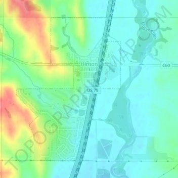
Name: Hinton topographic map, elevation, terrain.
Location: Hinton, Plymouth County, Iowa, 51204, United States (42.61197 -96.30898 42.63378 -96.28744)
Average elevation: 1,188 ft
Minimum elevation: 1,119 ft
Maximum elevation: 1,362 ft
Other topographic maps
Click on a map to view its topography, its elevation and its terrain.
Kingsley
United States > Iowa > Plymouth County
Kingsley, Plymouth County, Iowa, United States
Average elevation: 1,266 ft
Le Mars
United States > Iowa > Plymouth County
Le Mars, Plymouth County, Iowa, 51031, United States
Average elevation: 1,266 ft
Remsen
United States > Iowa > Plymouth County > Remsen
Remsen, Plymouth County, Iowa, United States
Average elevation: 1,342 ft