Geolocate

Corozal District topographic map

Interactive map

Click on the map to display elevation.

About this map

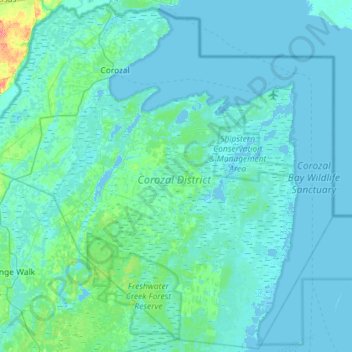
Name: Corozal District topographic map, elevation, terrain.

Location: Corozal District, Belize (17.96105 -88.60653 18.49591 -88.03037)

Average elevation: 16 ft

Minimum elevation: -10 ft

Maximum elevation: 246 ft

Other topographic maps

Click on a map to view its topography, its elevation and its terrain.

Caracol

Belize > Cayo District

Average elevation: 1,588 ft

Sarteneja

Belize > Corozal District

Average elevation: 7 ft

Toledo

Belize > Toledo District > Forest Home

Average elevation: 72 ft

Hummingbird Gap

Belize > Stann Creek District

Average elevation: 843 ft

Santa Marta

Belize > Cayo District

Average elevation: 449 ft

Cayo District

Belize > Cayo District

Average elevation: 2,175 ft

Ferguson Bank

Belize

Average elevation: 10 ft

New Land

Belize > Toledo District

Average elevation: 374 ft

Mafredi

Belize > Toledo District

Average elevation: 197 ft

San Antonia

Belize > Toledo District

Average elevation: 13 ft

Central Farm

Belize > Cayo District

Average elevation: 253 ft

San Antonio

Belize > Cayo District

Average elevation: 771 ft

Burrell Boom

Belize > Belize District

Average elevation: 23 ft

Patchakan

Belize > Corozal District

Average elevation: 26 ft

San Ignacio

Belize > Cayo > San Ignacio

Average elevation: 325 ft

Santa Cruz (Belize)

Belize > Toledo District

Average elevation: 1,053 ft

Springfield

Belize > Cayo

Average elevation: 581 ft

Hopkins

Belize > Stann Creek District > Hopkins

Average elevation: 7 ft

Corozal District

Belize > Corozal District

Average elevation: 85 ft

Long Caye

Belize > Belize District > Belize City

Average elevation: 0 ft

San José Succotz

Belize > Cayo > San José Succotz

Average elevation: 381 ft

Belize City

Belize > Belize District > Belize City

Average elevation: 3 ft