
Make a donation
Gear up for your next adventure:
As an Amazon Associate, this site earns from qualifying purchases at no extra cost to you.
Paris topographic map
Click on the map to display elevation.
Gear up for your next adventure:
As an Amazon Associate, this site earns from qualifying purchases at no extra cost to you.
Paris
Paris is situated on a relatively flat terrain, with its average elevation around 150 feet (45 meters) above sea level. The city lies within the Paris Basin, a low-lying area that was shaped over millennia by the meandering River Seine, which cuts through the city. Though generally flat, Paris is home to several notable hills, such as Montmartre (428 feet / 131 meters) and Belleville (422 feet / 129 meters), offering panoramic views across the city. The topography is further defined by the Seine’s presence, with the river having carved out valleys and leaving behind elevated terrains as it shifted over time. The highest point within Paris city limits is Montmartre, while the lowest is found near the western limits of the city, along the Seine.
Make a donation
Gear up for your next adventure:
As an Amazon Associate, this site earns from qualifying purchases at no extra cost to you.
About this map
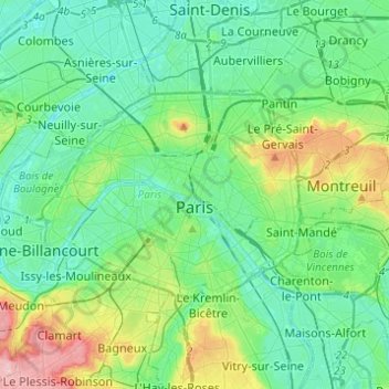
Name: Paris topographic map, elevation, terrain.
Location: Paris, Ile-de-France, Metropolitan France, France (48.81558 2.22412 48.90216 2.46976)
Average elevation: 194 ft
Minimum elevation: 69 ft
Maximum elevation: 614 ft
Make a donation
Gear up for your next adventure:
As an Amazon Associate, this site earns from qualifying purchases at no extra cost to you.
Other topographic maps
Click on a map to view its topography, its elevation and its terrain.
Parc de l'Abbaye du Lys
France > Ile-de-France > Seine-et-Marne > Dammarie-les-Lys
Average elevation: 217 ft
Paris Basin
France > Ile-de-France > Essonne > Bièvres
The landscape is one of very broad valleys (flood plains), modest watershed hills and well-drained plateaux of comparatively little altitude. In the south-east and east the plain of Champagne and the Seuil de Bourgogne (Threshold of Burgundy) differential erosion of the strata has left low scarps with the dip…
Average elevation: 413 ft
Make a donation
Gear up for your next adventure:
As an Amazon Associate, this site earns from qualifying purchases at no extra cost to you.
Make a donation
Gear up for your next adventure:
As an Amazon Associate, this site earns from qualifying purchases at no extra cost to you.
Résidence Parc de Béarn
France > Ile-de-France > Hauts-de-Seine > Saint-Cloud
Average elevation: 233 ft
Make a donation
Gear up for your next adventure:
As an Amazon Associate, this site earns from qualifying purchases at no extra cost to you.
Parc de Villette
France > Ile-de-France > Val-d'Oise > Condécourt > Villette
Average elevation: 282 ft
Make a donation
Gear up for your next adventure:
As an Amazon Associate, this site earns from qualifying purchases at no extra cost to you.
Mazagran
France > Ile-de-France > Seine-et-Marne > Saint-Denis-lès-Rebais > Mazagran
Average elevation: 486 ft
Val des Quatre Pignons
France > Ile-de-France > Yvelines > Beynes > Val des Quatre Pignons
Average elevation: 302 ft
Make a donation
Gear up for your next adventure:
As an Amazon Associate, this site earns from qualifying purchases at no extra cost to you.
Noisy-le-Grand
France > Ile-de-France > Seine-Saint-Denis > Noisy-le-Grand > Noisy-le-Grand
Average elevation: 230 ft
Parc de Billancourt
France > Ile-de-France > Hauts-de-Seine > Boulogne-Billancourt
Average elevation: 190 ft
Make a donation
Gear up for your next adventure:
As an Amazon Associate, this site earns from qualifying purchases at no extra cost to you.
Val Saint-Olaf
France > Ile-de-France > Hauts-de-Seine > Chaville > Val Saint-Olaf
Average elevation: 420 ft