
Make a donation
Gear up for your next adventure:
As an Amazon Associate, this site earns from qualifying purchases at no extra cost to you.
Cape May County topographic map
Click on the map to display elevation.
Make a donation
Gear up for your next adventure:
As an Amazon Associate, this site earns from qualifying purchases at no extra cost to you.
Cape May County
Cape May County is 29 mi (47 km) long and 15 mi (24 km) at its widest. According to the 2010 Census, the county had a total area of 620.42 square miles (1,606.9 km2), including 251.42 square miles (651.2 km2) of land (40.5%) and 368.99 square miles (955.7 km2) of water (59.5%). The county is located about 150 mi (240 km) south of New York City, 80 mi (130 km) southeast of Philadelphia, and 150 mi (240 km) east of Washington, D.C. To the south and east of the county is the Atlantic Ocean. The location near water provides milder temperatures than surrounding areas, as well as a continuous breeze, which contribute to the area's tourism-driven economy. Sea level along the coast is the lowest point. The highest elevation is found at three areas in Belleplain State Forest in the county's northern corner, which are approximately 60 ft (18 m) above sea level.
Make a donation
Gear up for your next adventure:
As an Amazon Associate, this site earns from qualifying purchases at no extra cost to you.
About this map
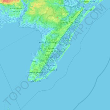
Name: Cape May County topographic map, elevation, terrain.
Location: Cape May County, New Jersey, United States (38.79113 -75.17705 39.32436 -74.49294)
Average elevation: 3 ft
Minimum elevation: -16 ft
Maximum elevation: 95 ft
New Jersey trails, hiking, mountain biking, running and outdoor activities
Make a donation
Gear up for your next adventure:
As an Amazon Associate, this site earns from qualifying purchases at no extra cost to you.
Other topographic maps
Click on a map to view its topography, its elevation and its terrain.
Pleasant Valley
United States > New Jersey > Morris County > Mendham Township
Average elevation: 512 ft
East Trenton Heights
United States > New Jersey > Mercer County > Hamilton Township
Average elevation: 72 ft
Make a donation
Gear up for your next adventure:
As an Amazon Associate, this site earns from qualifying purchases at no extra cost to you.
Lake Parsippany
United States > New Jersey > Morris County > Parsippany-Troy Hills
Average elevation: 305 ft
Make a donation
Gear up for your next adventure:
As an Amazon Associate, this site earns from qualifying purchases at no extra cost to you.
North Stelton
United States > New Jersey > Middlesex County > Piscataway Township
Average elevation: 95 ft
Randolphville
United States > New Jersey > Middlesex County > Piscataway Township
Average elevation: 85 ft
Make a donation
Gear up for your next adventure:
As an Amazon Associate, this site earns from qualifying purchases at no extra cost to you.
Randolphville
United States > New Jersey > Middlesex County > Piscataway Township
Average elevation: 85 ft
Paulas Corners
United States > New Jersey > Middlesex County > East Brunswick Township
Average elevation: 95 ft
Lawrence Brook Manor
United States > New Jersey > Middlesex County > East Brunswick Township
Average elevation: 62 ft
Make a donation
Gear up for your next adventure:
As an Amazon Associate, this site earns from qualifying purchases at no extra cost to you.
Robinsville
United States > New Jersey > Monmouth County > Upper Freehold Township
Average elevation: 184 ft
Croxton
United States > New Jersey > Hudson County > Jersey City > Journal Square
Average elevation: 52 ft
Wertsville
United States > New Jersey > Hunterdon County > East Amwell Township
Average elevation: 236 ft
Make a donation
Gear up for your next adventure:
As an Amazon Associate, this site earns from qualifying purchases at no extra cost to you.
Possumtown
United States > New Jersey > Middlesex County > Piscataway Township
Average elevation: 62 ft
Homes Mills
United States > New Jersey > Monmouth County > Upper Freehold Township
Average elevation: 112 ft
Charleston East
United States > New Jersey > Camden County > Cherry Hill Township
Average elevation: 75 ft
Make a donation
Gear up for your next adventure:
As an Amazon Associate, this site earns from qualifying purchases at no extra cost to you.
Van Marters Corner
United States > New Jersey > Monmouth County > Hazlet Township
Average elevation: 20 ft
Make a donation
Gear up for your next adventure:
As an Amazon Associate, this site earns from qualifying purchases at no extra cost to you.
Make a donation
Gear up for your next adventure:
As an Amazon Associate, this site earns from qualifying purchases at no extra cost to you.
Stow Acres
United States > New Jersey > Burlington County > Evesham Township > Marlton
Average elevation: 79 ft
Basking Ridge
United States > New Jersey > Somerset County > Bernards Township
Average elevation: 322 ft
Make a donation
Gear up for your next adventure:
As an Amazon Associate, this site earns from qualifying purchases at no extra cost to you.
Ferdinands Mills
United States > New Jersey > Bergen County > Franklin Lakes
Average elevation: 423 ft
Make a donation
Gear up for your next adventure:
As an Amazon Associate, this site earns from qualifying purchases at no extra cost to you.
Woolwich Township
United States > New Jersey > Gloucester County > Woolwich Township
Average elevation: 75 ft
Bishop Wood
United States > New Jersey > Camden County > Gloucester Township
Average elevation: 148 ft
Make a donation
Gear up for your next adventure:
As an Amazon Associate, this site earns from qualifying purchases at no extra cost to you.
Make a donation
Gear up for your next adventure:
As an Amazon Associate, this site earns from qualifying purchases at no extra cost to you.
Rahway River West Branch
United States > New Jersey > Essex County > Short Hills
Average elevation: 240 ft
Make a donation
Gear up for your next adventure:
As an Amazon Associate, this site earns from qualifying purchases at no extra cost to you.
Make a donation
Gear up for your next adventure:
As an Amazon Associate, this site earns from qualifying purchases at no extra cost to you.
Columbia Lakes
United States > New Jersey > Camden County > Cherry Hill Township
Average elevation: 56 ft
Remsterville
United States > New Jersey > Salem County > Alloway Township > Alloway Township
Average elevation: 49 ft
Make a donation
Gear up for your next adventure:
As an Amazon Associate, this site earns from qualifying purchases at no extra cost to you.
Powder Mill Pond Dam
United States > New Jersey > Morris County > Parsippany-Troy Hills > Tabor
Average elevation: 584 ft
Upper Mill
United States > New Jersey > Burlington County > Pemberton Township
Average elevation: 102 ft
Make a donation
Gear up for your next adventure:
As an Amazon Associate, this site earns from qualifying purchases at no extra cost to you.
Rock Mill
United States > New Jersey > Somerset County > Montgomery Township
Average elevation: 410 ft
Freneau Woods Park
United States > New Jersey > Monmouth County > Aberdeen Township > Henningers Mill
Average elevation: 75 ft
Mount Royal
United States > New Jersey > Gloucester County > East Greenwich Township
Average elevation: 36 ft
Make a donation
Gear up for your next adventure:
As an Amazon Associate, this site earns from qualifying purchases at no extra cost to you.
Lincoln
United States > New Jersey > Gloucester County > South Harrison Township
Average elevation: 121 ft
Make a donation
Gear up for your next adventure:
As an Amazon Associate, this site earns from qualifying purchases at no extra cost to you.
Kirbys Mill
United States > New Jersey > Burlington County > Medford Township
Average elevation: 49 ft
Washington Corner
United States > New Jersey > Morris County > Mendham Township
Average elevation: 571 ft
Make a donation
Gear up for your next adventure:
As an Amazon Associate, this site earns from qualifying purchases at no extra cost to you.
Fostertown
United States > New Jersey > Burlington County > Lumberton Township
Average elevation: 46 ft
Kirbys Mill
United States > New Jersey > Burlington County > Medford Township
Average elevation: 49 ft
Elmer B Boyd Park
United States > New Jersey > Middlesex County > New Brunswick > Feaster Park
Average elevation: 72 ft
Make a donation
Gear up for your next adventure:
As an Amazon Associate, this site earns from qualifying purchases at no extra cost to you.
Make a donation
Gear up for your next adventure:
As an Amazon Associate, this site earns from qualifying purchases at no extra cost to you.
Make a donation
Gear up for your next adventure:
As an Amazon Associate, this site earns from qualifying purchases at no extra cost to you.
Neshanic
United States > New Jersey > Somerset County > Hillsborough Township
Average elevation: 213 ft
Make a donation
Gear up for your next adventure:
As an Amazon Associate, this site earns from qualifying purchases at no extra cost to you.
Schooleys Mountain
United States > New Jersey > Morris County > Washington Township
Average elevation: 961 ft
Make a donation
Gear up for your next adventure:
As an Amazon Associate, this site earns from qualifying purchases at no extra cost to you.
Emleys Hill
United States > New Jersey > Monmouth County > Upper Freehold Township
Average elevation: 151 ft
Make a donation
Gear up for your next adventure:
As an Amazon Associate, this site earns from qualifying purchases at no extra cost to you.