
Belknap County topographic map
Interactive map
Click on the map to display elevation.
About this map
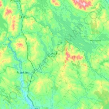
Name: Belknap County topographic map, elevation, terrain.
Location: Belknap County, New Hampshire, United States (43.28444 -71.73172 43.76476 -71.15894)
Average elevation: 751 ft
Minimum elevation: 243 ft
Maximum elevation: 2,923 ft
New Hampshire trails, hiking, mountain biking, running and outdoor activities
Other topographic maps
Click on a map to view its topography, its elevation and its terrain.
Mount Washington
United States > New Hampshire > Coos County
Mount Washington, in New Hampshire, is the highest peak in the Northeastern United States at 6,288.2 ft (1,916.6 m) and the most topographically prominent mountain east of the Mississippi River.
Average elevation: 5,144 ft
Mount Washington
United States > New Hampshire > Coos County
Mount Washington, also known as Agiocochook, is an ultra-prominent mountain in the state of New Hampshire. It is the highest peak in the Northeastern United States at 6,288.2 ft (1,916.6 m) and the most topographically prominent mountain east of the Mississippi River.
Average elevation: 5,144 ft
South Uncanoonuc Mountain
United States > New Hampshire > Hillsborough County > Goffstown
Average elevation: 797 ft
Mount Washington
United States > New Hampshire > Coos County
Mount Washington is an ultra-prominent mountain in the state of New Hampshire. It is the highest peak in the Northeastern United States at 6,288.2 ft (1,916.6 m) and the most topographically prominent mountain east of the Mississippi River.
Average elevation: 5,144 ft
Souhegan River
United States > New Hampshire > Hillsborough County > Milford > East Milford
Average elevation: 276 ft
Piscataquog River
United States > New Hampshire > Hillsborough County > Manchester
Average elevation: 194 ft
Souhegan River Watershed Dam Number 35
United States > New Hampshire > Hillsborough County > New Ipswich > Smithville
Average elevation: 1,145 ft
Gunstock Mountain
United States > New Hampshire > Belknap County > Gilford
Average elevation: 1,496 ft
East Washington
United States > New Hampshire > Sullivan County > Washington
Average elevation: 1,056 ft
Mount Adams
United States > New Hampshire > Coos County
Mount Adams, elevation 5,793 feet (1,766 m) above sea level, is a mountain in New Hampshire, the second highest peak in the Northeast United States after its nearby neighbor, Mount Washington. Located in the northern Presidential Range, Mount Adams was named after John Adams, the second President of the United…
Average elevation: 4,524 ft
Shaker Village
United States > New Hampshire > Merrimack County > Canterbury
Average elevation: 673 ft
Camp Notre Dame
United States > New Hampshire > Cheshire County > Chesterfield
Average elevation: 732 ft
West Peterborough
United States > New Hampshire > Hillsborough County > Peterborough
Average elevation: 981 ft
Gilboa Mountain
United States > New Hampshire > Cheshire County > Westmoreland
Average elevation: 1,086 ft
Mount Monadnock
United States > New Hampshire > Cheshire County > Jaffrey
From the base to the summit, floral species diminish with increasingly shallow soil levels. The summit is home to many different specialized sub-alpine species which can retain moisture for long periods of time. Alpine and sub-alpine species include mountain ash, cotton grass, sheep laurel, mountain sandwort,…
Average elevation: 2,254 ft
Jefferson Highland
United States > New Hampshire > Coos County > Jefferson
Average elevation: 1,480 ft
Stinson Lake
United States > New Hampshire > Grafton County > Rumney > Stinson Lake
Average elevation: 1,509 ft
Albany
United States > New Hampshire > Carroll County > Albany
According to the United States Census Bureau, the town has a total area of 75.8 square miles (196.2 km2), of which 75.1 square miles (194.6 km2) are land and 0.58 square miles (1.5 km2) are water, comprising 0.79% of the town. It is drained by the Swift River in the north and the Chocorua River in the south.…
Average elevation: 906 ft
Hillsboro Lower Village
United States > New Hampshire > Hillsborough County > Hillsborough
Average elevation: 794 ft
Providence Hill
United States > New Hampshire > Rockingham County > Atkinson
Average elevation: 236 ft
Campbell Mountain
United States > New Hampshire > Hillsborough County > Hillsborough
Average elevation: 1,109 ft
Mount Kineo, East Peak
United States > New Hampshire > Grafton County > Ellsworth
Average elevation: 2,329 ft
West Chesterfield
United States > New Hampshire > Cheshire County > Chesterfield
Average elevation: 551 ft
Massachusetts Drive Park
United States > New Hampshire > Hillsborough County > Nashua
Average elevation: 157 ft
Souhegan River
United States > New Hampshire > Hillsborough County > Milford > East Milford
Average elevation: 276 ft
Salem Depot
United States > New Hampshire > Rockingham County > Salem > Salem Depot
Average elevation: 164 ft
Rye Beach Village District
United States > New Hampshire > Rockingham County > Rye Beach Village District
Average elevation: 23 ft
West Lebanon
United States > New Hampshire > Grafton County > Lebanon > West Lebanon
Average elevation: 541 ft
North Brookline
United States > New Hampshire > Hillsborough County > Brookline > North Brookline
Average elevation: 407 ft
North Littleton
United States > New Hampshire > Grafton County > Littleton > North Littleton
Average elevation: 1,093 ft
North Village
United States > New Hampshire > Hillsborough County > Peterborough
Average elevation: 823 ft
LeBruns Mobile Home Park
United States > New Hampshire > Grafton County > Lebanon > LeBruns Mobile Home Park
Average elevation: 1,070 ft
Nakuru Lake
United States > New Hampshire > Hillsborough County > Hudson > Hudson Center
Average elevation: 262 ft