
Make a donation
Gear up for your next adventure:
As an Amazon Associate, this site earns from qualifying purchases at no extra cost to you.
Cary topographic map
Click on the map to display elevation.
Make a donation
Gear up for your next adventure:
As an Amazon Associate, this site earns from qualifying purchases at no extra cost to you.
Cary
Cary is seated on the boundary between the Durham Basin with its softer sedimentary rocks and the piedmont with its harder metamorphic rocks; both geologic provinces have igneous rock intrusions. The landscape is typically gentle to moderate sloping hills separated by narrow V-shaped valleys, but there are areas with steeper slopes and broader, U-shaped valleys in western Cary, roughly along NC 55 near the Research Triangle Park and north of Green Hope School Road. Cary's average elevation is 495 ft (151 m).
Make a donation
Gear up for your next adventure:
As an Amazon Associate, this site earns from qualifying purchases at no extra cost to you.
About this map
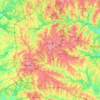
Name: Cary topographic map, elevation, terrain.
Location: Cary, Wake County, North Carolina, United States (35.64438 -78.95380 35.89688 -78.72946)
Average elevation: 364 ft
Minimum elevation: 197 ft
Maximum elevation: 525 ft
Wake County trails, hiking, mountain biking, running and outdoor activities
Make a donation
Gear up for your next adventure:
As an Amazon Associate, this site earns from qualifying purchases at no extra cost to you.
Other topographic maps
Click on a map to view its topography, its elevation and its terrain.
Lake Raleigh
United States > North Carolina > Wake County > Raleigh > Isle Forest
Average elevation: 341 ft
Make a donation
Gear up for your next adventure:
As an Amazon Associate, this site earns from qualifying purchases at no extra cost to you.
Prestonwood Soccer Complex
United States > North Carolina > Wake County > Cary
Average elevation: 364 ft
Lake Johnson
United States > North Carolina > Wake County > Raleigh > Orchards
Average elevation: 397 ft
Make a donation
Gear up for your next adventure:
As an Amazon Associate, this site earns from qualifying purchases at no extra cost to you.
Make a donation
Gear up for your next adventure:
As an Amazon Associate, this site earns from qualifying purchases at no extra cost to you.