
Porto Moniz topographic map
Interactive map
Click on the map to display elevation.
About this map
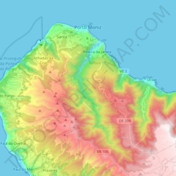
Name: Porto Moniz topographic map, elevation, terrain.
Location: Porto Moniz, Madeira, Portugal (32.76715 -17.23056 32.87062 -17.06541)
Average elevation: 1,749 ft
Minimum elevation: -3 ft
Maximum elevation: 5,108 ft
Other topographic maps
Click on a map to view its topography, its elevation and its terrain.
Soutelinho do Monte
Portugal > Vila Real > Vila Pouca de Aguiar > Vreia de Bornes
Average elevation: 1,893 ft
Mount Pico
Mount Pico (Portuguese: Montanha do Pico) is a currently dormant stratovolcano located on Pico Island, in the mid-Atlantic archipelago of the Azores. It is the highest mountain in Portugal, at 2,351 metres (7,713 ft) above sea level, and is one of the highest Atlantic mountains; it is more than twice the…
Average elevation: 5,558 ft
Inselberg de Monsanto
Portugal > Castelo Branco > Idanha-a-Nova > Adingeiro
Average elevation: 1,591 ft
Miradouro de São Pedro de Alcântara
Portugal > Lisbon > Lisbon > Misericórdia
Average elevation: 157 ft
Cidadelha de Jales
Portugal > Vila Real > Vila Pouca de Aguiar > Alfarela de Jales
Average elevation: 2,569 ft