
Make a donation
Gear up for your next adventure:
As an Amazon Associate, this site earns from qualifying purchases at no extra cost to you.
Passaic County topographic map
Click on the map to display elevation.
Make a donation
Gear up for your next adventure:
As an Amazon Associate, this site earns from qualifying purchases at no extra cost to you.
Passaic County
The highest point is any one of six areas on Bearfort Ridge in West Milford at approximately 1,480 feet (450 m) above sea level. The lowest elevation is approximately 20 feet (6.1 m) along the Passaic River in Clifton. The southeastern, more populous half of the county is either flat near the river or mildly hilly. The northwestern section is rugged and mountainous.
Make a donation
Gear up for your next adventure:
As an Amazon Associate, this site earns from qualifying purchases at no extra cost to you.
About this map
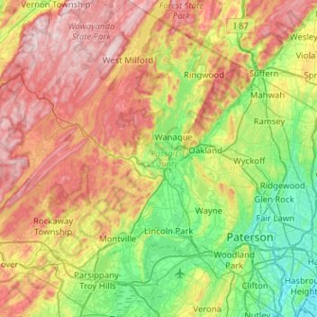
Name: Passaic County topographic map, elevation, terrain.
Location: Passaic County, New Jersey, United States (40.81993 -74.50321 41.20329 -74.10679)
Average elevation: 597 ft
Minimum elevation: 0 ft
Maximum elevation: 1,476 ft
New Jersey trails, hiking, mountain biking, running and outdoor activities
Make a donation
Gear up for your next adventure:
As an Amazon Associate, this site earns from qualifying purchases at no extra cost to you.
Other topographic maps
Click on a map to view its topography, its elevation and its terrain.
Randolphville
United States > New Jersey > Middlesex County > Piscataway Township
Average elevation: 85 ft
North Stelton
United States > New Jersey > Middlesex County > Piscataway Township
Average elevation: 95 ft
Randolphville
United States > New Jersey > Middlesex County > Piscataway Township
Average elevation: 85 ft
Make a donation
Gear up for your next adventure:
As an Amazon Associate, this site earns from qualifying purchases at no extra cost to you.
Paulas Corners
United States > New Jersey > Middlesex County > East Brunswick Township
Average elevation: 95 ft
Lawrence Brook Manor
United States > New Jersey > Middlesex County > East Brunswick Township
Average elevation: 62 ft
Make a donation
Gear up for your next adventure:
As an Amazon Associate, this site earns from qualifying purchases at no extra cost to you.
Robinsville
United States > New Jersey > Monmouth County > Upper Freehold Township
Average elevation: 184 ft
Croxton
United States > New Jersey > Hudson County > Jersey City > Journal Square
Average elevation: 52 ft
Wertsville
United States > New Jersey > Hunterdon County > East Amwell Township
Average elevation: 236 ft
Possumtown
United States > New Jersey > Middlesex County > Piscataway Township
Average elevation: 62 ft
Make a donation
Gear up for your next adventure:
As an Amazon Associate, this site earns from qualifying purchases at no extra cost to you.
Homes Mills
United States > New Jersey > Monmouth County > Upper Freehold Township
Average elevation: 112 ft
Charleston East
United States > New Jersey > Camden County > Cherry Hill Township
Average elevation: 75 ft
Make a donation
Gear up for your next adventure:
As an Amazon Associate, this site earns from qualifying purchases at no extra cost to you.
Van Marters Corner
United States > New Jersey > Monmouth County > Hazlet Township
Average elevation: 20 ft
Make a donation
Gear up for your next adventure:
As an Amazon Associate, this site earns from qualifying purchases at no extra cost to you.
Make a donation
Gear up for your next adventure:
As an Amazon Associate, this site earns from qualifying purchases at no extra cost to you.
Stow Acres
United States > New Jersey > Burlington County > Evesham Township > Marlton
Average elevation: 79 ft
Basking Ridge
United States > New Jersey > Somerset County > Bernards Township
Average elevation: 322 ft
Make a donation
Gear up for your next adventure:
As an Amazon Associate, this site earns from qualifying purchases at no extra cost to you.
Ferdinands Mills
United States > New Jersey > Bergen County > Franklin Lakes
Average elevation: 423 ft
Woolwich Township
United States > New Jersey > Gloucester County > Woolwich Township
Average elevation: 75 ft
Make a donation
Gear up for your next adventure:
As an Amazon Associate, this site earns from qualifying purchases at no extra cost to you.
Bishop Wood
United States > New Jersey > Camden County > Gloucester Township
Average elevation: 148 ft
Make a donation
Gear up for your next adventure:
As an Amazon Associate, this site earns from qualifying purchases at no extra cost to you.
Make a donation
Gear up for your next adventure:
As an Amazon Associate, this site earns from qualifying purchases at no extra cost to you.
Rahway River West Branch
United States > New Jersey > Essex County > Short Hills
Average elevation: 240 ft
Make a donation
Gear up for your next adventure:
As an Amazon Associate, this site earns from qualifying purchases at no extra cost to you.
Make a donation
Gear up for your next adventure:
As an Amazon Associate, this site earns from qualifying purchases at no extra cost to you.
Columbia Lakes
United States > New Jersey > Camden County > Cherry Hill Township
Average elevation: 56 ft
Remsterville
United States > New Jersey > Salem County > Alloway Township > Alloway Township
Average elevation: 49 ft
Powder Mill Pond Dam
United States > New Jersey > Morris County > Parsippany-Troy Hills > Tabor
Average elevation: 584 ft
Make a donation
Gear up for your next adventure:
As an Amazon Associate, this site earns from qualifying purchases at no extra cost to you.
Upper Mill
United States > New Jersey > Burlington County > Pemberton Township
Average elevation: 102 ft
Make a donation
Gear up for your next adventure:
As an Amazon Associate, this site earns from qualifying purchases at no extra cost to you.
Rock Mill
United States > New Jersey > Somerset County > Montgomery Township
Average elevation: 410 ft
Freneau Woods Park
United States > New Jersey > Monmouth County > Aberdeen Township > Henningers Mill
Average elevation: 75 ft
Mount Royal
United States > New Jersey > Gloucester County > East Greenwich Township
Average elevation: 36 ft
Make a donation
Gear up for your next adventure:
As an Amazon Associate, this site earns from qualifying purchases at no extra cost to you.
Lincoln
United States > New Jersey > Gloucester County > South Harrison Township
Average elevation: 121 ft
Kirbys Mill
United States > New Jersey > Burlington County > Medford Township
Average elevation: 49 ft
Make a donation
Gear up for your next adventure:
As an Amazon Associate, this site earns from qualifying purchases at no extra cost to you.
Washington Corner
United States > New Jersey > Morris County > Mendham Township
Average elevation: 571 ft
Fostertown
United States > New Jersey > Burlington County > Lumberton Township
Average elevation: 46 ft
Make a donation
Gear up for your next adventure:
As an Amazon Associate, this site earns from qualifying purchases at no extra cost to you.
Kirbys Mill
United States > New Jersey > Burlington County > Medford Township
Average elevation: 49 ft
Elmer B Boyd Park
United States > New Jersey > Middlesex County > New Brunswick > Feaster Park
Average elevation: 72 ft
Make a donation
Gear up for your next adventure:
As an Amazon Associate, this site earns from qualifying purchases at no extra cost to you.
Make a donation
Gear up for your next adventure:
As an Amazon Associate, this site earns from qualifying purchases at no extra cost to you.
Make a donation
Gear up for your next adventure:
As an Amazon Associate, this site earns from qualifying purchases at no extra cost to you.
Neshanic
United States > New Jersey > Somerset County > Hillsborough Township
Average elevation: 213 ft
Make a donation
Gear up for your next adventure:
As an Amazon Associate, this site earns from qualifying purchases at no extra cost to you.
Schooleys Mountain
United States > New Jersey > Morris County > Washington Township
Average elevation: 961 ft
Make a donation
Gear up for your next adventure:
As an Amazon Associate, this site earns from qualifying purchases at no extra cost to you.
Emleys Hill
United States > New Jersey > Monmouth County > Upper Freehold Township
Average elevation: 151 ft
Hendrickson Corners
United States > New Jersey > Monmouth County > Middletown Township
Average elevation: 72 ft
Make a donation
Gear up for your next adventure:
As an Amazon Associate, this site earns from qualifying purchases at no extra cost to you.
Hillside Terrace
United States > New Jersey > Mercer County > Robbinsville Township
Average elevation: 115 ft
Make a donation
Gear up for your next adventure:
As an Amazon Associate, this site earns from qualifying purchases at no extra cost to you.
Make a donation
Gear up for your next adventure:
As an Amazon Associate, this site earns from qualifying purchases at no extra cost to you.