
Tompkins County topographic map
Interactive map
Click on the map to display elevation.
About this map
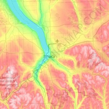
Name: Tompkins County topographic map, elevation, terrain.
Location: Tompkins County, New York, United States (42.26275 -76.69654 42.62741 -76.23766)
Average elevation: 1,237 ft
Minimum elevation: 354 ft
Maximum elevation: 2,100 ft
New York trails, hiking, mountain biking, running and outdoor activities
Other topographic maps
Click on a map to view its topography, its elevation and its terrain.
Central Park
United States > New York > New York County > New York
In June 1856, Fernando Wood appointed a "consulting board" of seven people, headed by author Washington Irving, to inspire public confidence in the proposed development. Wood hired military engineer Egbert Ludovicus Viele as the park's chief engineer, tasking him with a topographical survey of the site. The…
Average elevation: 85 ft
South Ridge
United States > New York > Westchester County > Village of Rye Brook
Average elevation: 121 ft
Ulster Heights
United States > New York > Ulster County > Town of Wawarsing
Average elevation: 1,099 ft
Kent Cliffs Unit
United States > New York > Putnam County > Town of Putnam Valley > Richardsville
Average elevation: 886 ft
Murdock Woods
United States > New York > Westchester County > Town of Mamaroneck
Average elevation: 151 ft
Maple Mountain
United States > New York > Saint Lawrence County > Town of Fine
Average elevation: 1,562 ft
North Clymer
United States > New York > Chautauqua County > Town of Clymer
Average elevation: 1,663 ft
Turkey Mountain
United States > New York > Westchester County > Town of Yorktown
Average elevation: 466 ft
Hartung-Boothroyd Observatory
United States > New York > Tompkins County > Town of Dryden > Varna
The primary 0.6m mirror was constructed from a Pyrex 1/8-scale test pouring as part of technology development for the Palomar Observatory 200-inch telescope. The mirror was polished and mounted in a lightweight tube in the late 1930s under Boothroyd's direction, but World War II deferred its planned use in a…
Average elevation: 1,565 ft
Tomkins Cove
United States > New York > Rockland County > Town of Stony Point
Average elevation: 223 ft
Sleepy Hollow Manor
United States > New York > Westchester County > Village of Sleepy Hollow
Average elevation: 135 ft
Wurlitzer Park Village
United States > New York > Niagara County > City of North Tonawanda
Average elevation: 584 ft
Fort Miller
United States > New York > Washington County > Town of Fort Edward
Average elevation: 184 ft
French Mountain
United States > New York > Warren County > Town of Queensbury
Average elevation: 1,040 ft
West Jefferson
United States > New York > Schoharie County > Town of Jefferson
Average elevation: 1,929 ft
North Chittenango
United States > New York > Madison County > Town of Sullivan
Average elevation: 417 ft
Stillwater Pond
United States > New York > Putnam County > Town of Putnam Valley
Average elevation: 945 ft
Woodland Valley Campground
United States > New York > Ulster County > Town of Shandaken
Average elevation: 1,854 ft
Albany Pine Bush Preserve
United States > New York > Albany County > City of Albany
Average elevation: 279 ft
Just Room Enough Island
United States > New York > Jefferson County > Village of Alexandria Bay
Average elevation: 256 ft
Furnace Woods
United States > New York > Westchester County > Town of Cortlandt
Average elevation: 381 ft
Hampton Park
United States > New York > Suffolk County > North Sea > Town of Southampton
Average elevation: 56 ft
Cameron Mills
United States > New York > Steuben County > Town of Rathbone
Average elevation: 1,411 ft