Geolocate
Thank you for supporting this site ❤️
Make a donation

Walla Walla County topographic map

Interactive map

Click on the map to display elevation.

About this map

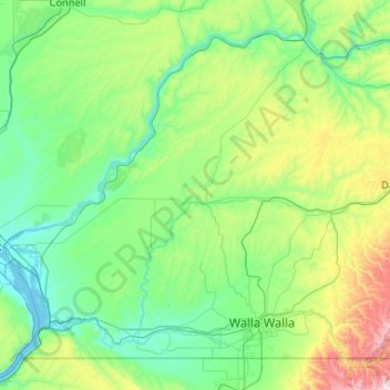
Name: Walla Walla County topographic map, elevation, terrain.

Location: Walla Walla County, Washington, United States (45.99986 -119.03639 46.60711 -117.99129)

Average elevation: 1,211 ft

Minimum elevation: 335 ft

Maximum elevation: 5,499 ft

Washington trails, hiking, mountain biking, running and outdoor activities

Other topographic maps

Click on a map to view its topography, its elevation and its terrain.

Cleveland

United States > Washington > Klickitat County

Average elevation: 3,107 ft

Snowden

United States > Washington > Klickitat County

Average elevation: 2,247 ft

Husum

United States > Washington > Klickitat County

Average elevation: 712 ft

Valleyford

United States > Washington > Spokane County

Average elevation: 2,503 ft

Beebe

United States > Washington > Douglas County

Average elevation: 1,214 ft

Glenoma

United States > Washington > Lewis County

Average elevation: 1,161 ft

Beebe

United States > Washington > Douglas County

Average elevation: 1,214 ft

Millet Lake

United States > Washington > Clark County

Average elevation: 75 ft

Puget Sound

United States > Washington > Edmonds

Average elevation: 0 ft

Enterprise

United States > Washington > Stevens County

Average elevation: 1,962 ft

Deer Lake

United States > Washington > King County

Average elevation: 3,783 ft

Bissel

United States > Washington > Stevens County

Average elevation: 2,110 ft

Tumtum

United States > Washington > Stevens County

Average elevation: 1,821 ft

Blanchard

United States > Washington > Skagit County

Average elevation: 161 ft

Rice

United States > Washington > Stevens County

Average elevation: 1,759 ft

Turk

United States > Washington > Stevens County

Average elevation: 3,114 ft

Mount Saint Helens

United States > Washington > Skamania County

The Mount St. Helens major eruption of May 18, 1980 remains the deadliest and most economically destructive volcanic event in U.S. history. Fifty-seven people were killed; 200 homes, 47 bridges, 15 miles (24 km) of railways, and 185 miles (298 km) of highway were destroyed. A massive debris avalanche,…

Average elevation: 6,877 ft

Putrid Pete's Peak

United States > Washington > King County

Average elevation: 3,770 ft

Mazama

United States > Washington > Okanogan County

Average elevation: 2,713 ft

Babcock Ridge Lake

United States > Washington > Grant County

Average elevation: 1,339 ft

Henrys

United States > Washington > King County > Maple Valley

Average elevation: 610 ft

Mica Peak

United States > Washington > Spokane County

Mica Peak is the name of two separate mountain summits in the United States located approximately 5.49 miles (9 km) apart; one in Spokane County, Washington and the other in Kootenai County, Idaho. The two peaks are located along the same ridge, which separates the Spokane Valley and Rathdrum Prairie from the…

Average elevation: 4,301 ft

Lester

United States > Washington > King County

Lester is located, east of Enumclaw, Washington along the Green River and BNSF Railway line. Its elevation is 1,634 feet (498 m) above sea level.

Average elevation: 2,264 ft

Newport Hills

United States > Washington > King County > Newcastle

Average elevation: 338 ft

Wenas

United States > Washington > Yakima County

Average elevation: 2,474 ft

Mount Rainier

United States > Washington > Pierce County

Mount Rainier (/reɪˈnɪər/ ray-NEER), also known as Tahoma, is a large active stratovolcano in the Cascade Range of the Pacific Northwest in the United States. The mountain is located in Mount Rainier National Park about 59 miles (95 km) south-southeast of Seattle. With an officially recognized summit…

Average elevation: 12,831 ft

Chumstick

United States > Washington > Chelan County

Average elevation: 2,070 ft

Lone Butte

United States > Washington > Skamania County

Average elevation: 3,606 ft

Mount Adams

United States > Washington > Yakima County

Adams is one of the long-lived volcanoes in the Cascade Range, with minor activity beginning 900,000 years ago and major cone building activity beginning 520,000 years ago. The whole mountain has been completely eroded by glaciers to an elevation of 8,200 feet (2,500 m) twice during its lifetime. The current…

Average elevation: 10,614 ft

Mount Brynion

United States > Washington > Cowlitz County

Average elevation: 1,014 ft

Galena

United States > Washington > Snohomish County

Average elevation: 2,241 ft

Mission Ridge

United States > Washington > Chelan County

Average elevation: 3,730 ft

Seabeck

United States > Washington > Kitsap County

Average elevation: 190 ft

Mount Si

United States > Washington > King County

The peak can be accessed by two trails. The Old Mount Si trail is accessed by the Little Si parking lot and the Boulder Garden Loop. It is 0.6 miles (0.97 km) shorter, 270 feet (82 m) steeper in elevation gain, and less crowded than the main trail. The Mount Si trail is accessed by the Mount Si parking lot.

Average elevation: 2,582 ft

Mud Mountain Dam

United States > Washington > King County

Average elevation: 1,378 ft

Wenas Lake

United States > Washington > Yakima County

Average elevation: 2,070 ft

Home Valley

United States > Washington > Skamania County

Average elevation: 230 ft

Mount Ellinor

United States > Washington > Mason County

Mount Ellinor is a peak in the Olympic Mountains of Washington, United States. It is located in an area designated as the Mount Skokomish Wilderness. The mountain is a popular day hike in the summer months; the summit is reachable via a steep-but-brief 3.3-mile (5.3 km) trail which gains about 3,200 feet (980…

Average elevation: 4,377 ft

Mount Tolman

United States > Washington > Ferry County

Average elevation: 2,375 ft

Mount Adams

United States > Washington > Yakima County

Adams is one of the long-lived volcanoes in the Cascade Range, with minor activity beginning 900,000 years ago and major cone building activity beginning 520,000 years ago. The whole mountain has been completely eroded by glaciers to an elevation of 8,200 feet (2,500 m) twice during its lifetime. The current…

Average elevation: 10,614 ft

Grays

United States > Washington > Stevens County

Average elevation: 1,962 ft

Monitor

United States > Washington > Chelan County

Average elevation: 1,102 ft

Cathedral Rock

United States > Washington > Kittitas County

Cathedral Rock is an intrusive andesite volcanic complex. The Alpine Lakes Wilderness features some of the most rugged topography in the Cascade Range with craggy peaks and ridges, deep glacial valleys, and granite walls spotted with over 700 mountain lakes. Geological events occurring many years ago created…

Average elevation: 5,075 ft

Teanaway

United States > Washington > Kittitas County

Average elevation: 1,942 ft

Reiter

United States > Washington > Snohomish County

Average elevation: 738 ft

Hilltop

United States > Washington > King County > Bellevue

Average elevation: 636 ft

Laurel

United States > Washington > Whatcom County

Average elevation: 105 ft

Winton

United States > Washington > Chelan County

Average elevation: 2,612 ft

Wenas

United States > Washington > Yakima County

Average elevation: 2,474 ft

Seattle Center

United States > Washington > King County > Seattle

Average elevation: 121 ft

Glenwood

United States > Washington > Kitsap County

Average elevation: 344 ft

Lincoln

United States > Washington > Kitsap County > Poulsbo

Average elevation: 249 ft

High Point

United States > Washington > King County

Average elevation: 1,020 ft

The Brothers

United States > Washington > Jefferson County

Average elevation: 4,820 ft

Duckabush

United States > Washington > Jefferson County

Average elevation: 233 ft

Twisp River

United States > Washington > Okanogan County > Twisp

Average elevation: 3,350 ft

Nooksack Cirque

United States > Washington > Whatcom County

Average elevation: 4,777 ft

Mount Stuart

United States > Washington > Chelan County

Mount Stuart is more notable for its local relief than for its absolute elevation. For example, the south face rises 5,000 feet (1,500 m) in just 2 horizontal miles (3.2 km). The northeast and northwest sides of the mountain exhibit similar steep relief. Due to its location away from higher peaks, Mount Stuart…

Average elevation: 6,919 ft

Palouse River

United States > Washington > Whitman County

Average elevation: 1,004 ft

Almota

United States > Washington > Whitman County

Average elevation: 1,112 ft

McAlester Lake

United States > Washington > Chelan County

Average elevation: 5,820 ft

Factoria

United States > Washington > King County > Bellevue

Average elevation: 246 ft

Hot Springs

United States > Washington > King County

Hot Springs is located east of Enumclaw and just west of Lester, along the Green River and BNSF Railway line. Its elevation is 1512 feet (460m) above sea level.

Average elevation: 1,929 ft

Hat Island

United States > Washington > Snohomish County

Average elevation: 30 ft

Flora Mountain

United States > Washington > Chelan County

Average elevation: 6,778 ft

Mount Saint Helens

United States > Washington > Skamania County

The Mount St. Helens major eruption of May 18, 1980, remains the deadliest and most economically destructive volcanic event in U.S. history. Fifty-seven people were killed; 200 homes, 47 bridges, 15 miles (24 km) of railways, and 185 miles (298 km) of highway were destroyed. A massive debris avalanche,…

Average elevation: 6,877 ft

Grotto

United States > Washington > King County

Average elevation: 3,576 ft

Russian Butte

United States > Washington > King County

Average elevation: 3,205 ft

Seabeck

United States > Washington > Kitsap County

Average elevation: 190 ft

Weallup Lake

United States > Washington > Snohomish County

Average elevation: 367 ft

Rosario Beach

United States > Washington > Skagit County

Average elevation: 151 ft

Newport Hills

United States > Washington > King County > Newcastle

Average elevation: 338 ft

Oceanside

United States > Washington > Pacific County

Average elevation: 13 ft

Irby

United States > Washington > Lincoln County

Average elevation: 1,565 ft

Bunker

United States > Washington > Lewis County

Average elevation: 331 ft

Port Gamble

United States > Washington > Kitsap County

Average elevation: 102 ft

Appleton

United States > Washington > Klickitat County

Average elevation: 2,362 ft

Wright Park

United States > Washington > Pierce County > Tacoma

Average elevation: 187 ft

West Valley

United States > Washington > Yakima County > Yakima

Average elevation: 1,270 ft

Boyd Hill

United States > Washington > Pierce County

Average elevation: 351 ft

Bug Lake

United States > Washington > Whatcom County > Bellingham

Average elevation: 138 ft

Queen Anne Hill

United States > Washington > King County > Seattle

Average elevation: 180 ft

Long Marsh

United States > Washington > King County

Average elevation: 879 ft

Point Migley

United States > Washington > Whatcom County

Average elevation: 30 ft

Manitou

United States > Washington > King County > Kirkland

Average elevation: 190 ft

Birdsview

United States > Washington > Skagit County

Average elevation: 240 ft

Peshastin

United States > Washington > Chelan County

Average elevation: 1,371 ft

Riverton

United States > Washington > King County > Tukwila

Average elevation: 253 ft