
Warren County topographic map
Interactive map
Click on the map to display elevation.
Warren County
The highest elevation is 1,600 feet (490 m) above sea level on the Kittatinny Ridge, at two areas just south of Upper Yards Creek Reservoir, west of Blairstown. The lowest point is the confluence of the Delaware and Musconetcong rivers at the county's southern tip, at 160 feet (49 m) of elevation.
About this map
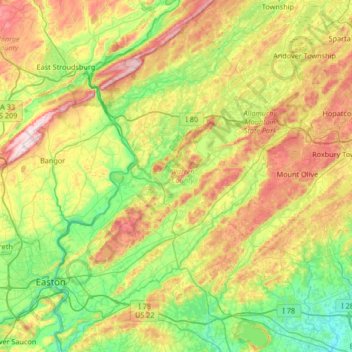
Name: Warren County topographic map, elevation, terrain.
Location: Warren County, New Jersey, United States (40.59172 -75.20407 41.09460 -74.76873)
Average elevation: 630 ft
Minimum elevation: 62 ft
Maximum elevation: 1,690 ft
New Jersey trails, hiking, mountain biking, running and outdoor activities
Other topographic maps
Click on a map to view its topography, its elevation and its terrain.
Ferdinands Mills
United States > New Jersey > Bergen County > Franklin Lakes
Average elevation: 423 ft
Woolwich Township
United States > New Jersey > Gloucester County > Woolwich Township
Average elevation: 75 ft
Bishop Wood
United States > New Jersey > Camden County > Gloucester Township
Average elevation: 148 ft
Rahway River West Branch
United States > New Jersey > Essex County > Short Hills
Average elevation: 240 ft
Columbia Lakes
United States > New Jersey > Camden County > Cherry Hill Township
Average elevation: 56 ft
Remsterville
United States > New Jersey > Salem County > Alloway Township > Alloway Township
Average elevation: 49 ft
Powder Mill Pond Dam
United States > New Jersey > Morris County > Parsippany-Troy Hills > Tabor
Average elevation: 584 ft
Basking Ridge
United States > New Jersey > Somerset County > Bernards Township
Average elevation: 322 ft
Rock Mill
United States > New Jersey > Somerset County > Montgomery Township
Average elevation: 410 ft
Freneau Woods Park
United States > New Jersey > Monmouth County > Aberdeen Township > Henningers Mill
Average elevation: 75 ft
Upper Mill
United States > New Jersey > Burlington County > Pemberton Township
Average elevation: 102 ft
Kirbys Mill
United States > New Jersey > Burlington County > Medford Township
Average elevation: 49 ft
Mount Royal
United States > New Jersey > Gloucester County > East Greenwich Township
Average elevation: 36 ft
Fostertown
United States > New Jersey > Burlington County > Lumberton Township
Average elevation: 46 ft
Lincoln
United States > New Jersey > Gloucester County > South Harrison Township
Average elevation: 121 ft
Kirbys Mill
United States > New Jersey > Burlington County > Medford Township
Average elevation: 49 ft
Washington Corner
United States > New Jersey > Morris County > Mendham Township
Average elevation: 571 ft
Neshanic
United States > New Jersey > Somerset County > Hillsborough Township
Average elevation: 213 ft
Elmer B Boyd Park
United States > New Jersey > Middlesex County > New Brunswick > Feaster Park
Average elevation: 72 ft
Hendrickson Corners
United States > New Jersey > Monmouth County > Middletown Township
Average elevation: 72 ft
Emleys Hill
United States > New Jersey > Monmouth County > Upper Freehold Township
Average elevation: 151 ft
Hillside Terrace
United States > New Jersey > Mercer County > Robbinsville Township
Average elevation: 115 ft
Hendrickson Corners
United States > New Jersey > Monmouth County > Middletown Township
Average elevation: 72 ft
Downs Farms
United States > New Jersey > Camden County > Cherry Hill Township
Average elevation: 79 ft
Schooleys Mountain
United States > New Jersey > Morris County > Washington Township
Average elevation: 961 ft
Marlboro
United States > New Jersey > Burlington County > Evesham Township > Marlton
Average elevation: 85 ft
Burlington Heights
United States > New Jersey > Monmouth County > Freehold Township
Average elevation: 154 ft
Alloway Township
United States > New Jersey > Salem County > Alloway Township
Average elevation: 46 ft
Marion
United States > New Jersey > Hudson County > Jersey City > Journal Square
Average elevation: 39 ft
Croxton
United States > New Jersey > Hudson County > Jersey City > Journal Square
Average elevation: 52 ft
High Rock Mountain
United States > New Jersey > Warren County > White Township
Average elevation: 620 ft
West Keansburg
United States > New Jersey > Monmouth County > Hazlet Township
Average elevation: 13 ft
Bearfort Mountain
United States > New Jersey > Passaic County > West Milford
At an elevation of 1,331 feet (406 m) the ridge is the site of a 68 feet (21 m) high fire lookout tower built by the New Jersey Forest Fire Service.
Average elevation: 1,161 ft