
Make a donation
Gear up for your next adventure:
As an Amazon Associate, this site earns from qualifying purchases at no extra cost to you.
Warren County topographic map
Click on the map to display elevation.
Make a donation
Gear up for your next adventure:
As an Amazon Associate, this site earns from qualifying purchases at no extra cost to you.
Warren County
The highest elevation is 1,600 feet (490 m) above sea level on the Kittatinny Ridge, at two areas just south of Upper Yards Creek Reservoir, west of Blairstown. The lowest point is the confluence of the Delaware and Musconetcong rivers at the county's southern tip, at 160 feet (49 m) of elevation.
Make a donation
Gear up for your next adventure:
As an Amazon Associate, this site earns from qualifying purchases at no extra cost to you.
About this map
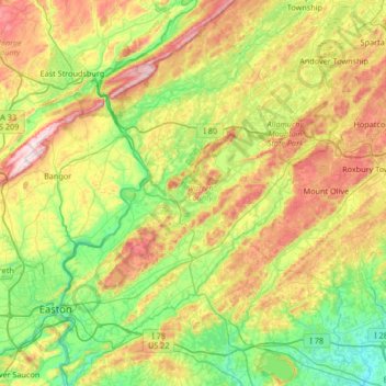
Name: Warren County topographic map, elevation, terrain.
Location: Warren County, New Jersey, United States (40.59172 -75.20407 41.09460 -74.76873)
Average elevation: 630 ft
Minimum elevation: 62 ft
Maximum elevation: 1,690 ft
New Jersey trails, hiking, mountain biking, running and outdoor activities
Make a donation
Gear up for your next adventure:
As an Amazon Associate, this site earns from qualifying purchases at no extra cost to you.
Other topographic maps
Click on a map to view its topography, its elevation and its terrain.
Bishops
United States > New Jersey > Camden County > Waterford Township > Atco
Average elevation: 154 ft
Make a donation
Gear up for your next adventure:
As an Amazon Associate, this site earns from qualifying purchases at no extra cost to you.
Kenvil
United States > New Jersey > Morris County > Roxbury Township > Succasunna
Average elevation: 784 ft
Make a donation
Gear up for your next adventure:
As an Amazon Associate, this site earns from qualifying purchases at no extra cost to you.
Raven Rock
United States > New Jersey > Hunterdon County > Delaware Township
Average elevation: 285 ft
Centerville
United States > New Jersey > Hunterdon County > Readington Township
Average elevation: 161 ft
Make a donation
Gear up for your next adventure:
As an Amazon Associate, this site earns from qualifying purchases at no extra cost to you.
North Stelton
United States > New Jersey > Middlesex County > Piscataway Township
Average elevation: 95 ft
Washington Valley
United States > New Jersey > Morris County > Morris Township
Average elevation: 499 ft
Make a donation
Gear up for your next adventure:
As an Amazon Associate, this site earns from qualifying purchases at no extra cost to you.
Make a donation
Gear up for your next adventure:
As an Amazon Associate, this site earns from qualifying purchases at no extra cost to you.
High Rock Mountain
United States > New Jersey > Warren County > White Township
Average elevation: 620 ft
Downs Farms
United States > New Jersey > Camden County > Cherry Hill Township
Average elevation: 79 ft
Make a donation
Gear up for your next adventure:
As an Amazon Associate, this site earns from qualifying purchases at no extra cost to you.
Basking Ridge
United States > New Jersey > Somerset County > Bernards Township
Average elevation: 322 ft
Make a donation
Gear up for your next adventure:
As an Amazon Associate, this site earns from qualifying purchases at no extra cost to you.
Make a donation
Gear up for your next adventure:
As an Amazon Associate, this site earns from qualifying purchases at no extra cost to you.
Lincoln
United States > New Jersey > Gloucester County > South Harrison Township
Average elevation: 121 ft
Freneau Woods Park
United States > New Jersey > Monmouth County > Aberdeen Township > Henningers Mill
Average elevation: 75 ft
Make a donation
Gear up for your next adventure:
As an Amazon Associate, this site earns from qualifying purchases at no extra cost to you.
Croxton
United States > New Jersey > Hudson County > Jersey City > Journal Square
Average elevation: 52 ft
Make a donation
Gear up for your next adventure:
As an Amazon Associate, this site earns from qualifying purchases at no extra cost to you.
Echo Lake Park
United States > New Jersey > Monmouth County > Howell Township
Average elevation: 85 ft
Ringoes
United States > New Jersey > Hunterdon County > East Amwell Township
Average elevation: 246 ft
Make a donation
Gear up for your next adventure:
As an Amazon Associate, this site earns from qualifying purchases at no extra cost to you.
Frost Woods Park
United States > New Jersey > Middlesex County > East Brunswick Township
Average elevation: 95 ft
Monroeville
United States > New Jersey > Salem County > Upper Pittsgrove Township
Average elevation: 131 ft
Make a donation
Gear up for your next adventure:
As an Amazon Associate, this site earns from qualifying purchases at no extra cost to you.
Make a donation
Gear up for your next adventure:
As an Amazon Associate, this site earns from qualifying purchases at no extra cost to you.
Hampton Gate
United States > New Jersey > Burlington County > Tabernacle Township
Average elevation: 79 ft
Make a donation
Gear up for your next adventure:
As an Amazon Associate, this site earns from qualifying purchases at no extra cost to you.
Sunset Beach
United States > New Jersey > Gloucester County > Deptford Township
Average elevation: 56 ft
Make a donation
Gear up for your next adventure:
As an Amazon Associate, this site earns from qualifying purchases at no extra cost to you.
East Riverton
United States > New Jersey > Burlington County > Cinnaminson Township > Riverton
Average elevation: 30 ft
Make a donation
Gear up for your next adventure:
As an Amazon Associate, this site earns from qualifying purchases at no extra cost to you.
Barnegat Beach
United States > New Jersey > Ocean County > Ocean Township > Waretown
Average elevation: 13 ft
Township of Wayne McCoog Park
United States > New Jersey > Passaic County > Wayne
Average elevation: 180 ft
Make a donation
Gear up for your next adventure:
As an Amazon Associate, this site earns from qualifying purchases at no extra cost to you.
Green Curve Heights
United States > New Jersey > Mercer County > Ewing Township
Average elevation: 131 ft
Make a donation
Gear up for your next adventure:
As an Amazon Associate, this site earns from qualifying purchases at no extra cost to you.
High Point
United States > New Jersey > Sussex County > Montague Township
High Point is a mountain peak within High Point State Park on the border of Wantage Township and Montague Township, Sussex County, New Jersey. Located in the portion of the state known as the Skylands, it is the highest elevation in the state, with a peak elevation of 1,803 feet (550 m). The closest city is…
Average elevation: 1,362 ft
Make a donation
Gear up for your next adventure:
As an Amazon Associate, this site earns from qualifying purchases at no extra cost to you.
Make a donation
Gear up for your next adventure:
As an Amazon Associate, this site earns from qualifying purchases at no extra cost to you.
Make a donation
Gear up for your next adventure:
As an Amazon Associate, this site earns from qualifying purchases at no extra cost to you.
Creesville
United States > New Jersey > Gloucester County > Washington Township
Average elevation: 105 ft
Make a donation
Gear up for your next adventure:
As an Amazon Associate, this site earns from qualifying purchases at no extra cost to you.
Middlesex Downs
United States > New Jersey > Middlesex County > Monroe Township
Average elevation: 108 ft
Make a donation
Gear up for your next adventure:
As an Amazon Associate, this site earns from qualifying purchases at no extra cost to you.
Make a donation
Gear up for your next adventure:
As an Amazon Associate, this site earns from qualifying purchases at no extra cost to you.
Burlington Heights
United States > New Jersey > Monmouth County > Freehold Township
Average elevation: 154 ft
Hendrickson Corners
United States > New Jersey > Monmouth County > Middletown Township
Average elevation: 72 ft
Make a donation
Gear up for your next adventure:
As an Amazon Associate, this site earns from qualifying purchases at no extra cost to you.