Geolocate

White County topographic map

Interactive map

Click on the map to display elevation.

White County

The county is mostly located in the foothills of the Blue Ridge Mountains. Northern parts of the county have the highest elevations, being in the mountains themselves. The highest point in White County is 4,430-foot (1,350 m) Tray Mountain, shared with Towns County to the north. Tray Mountain is the 6th-highest mountain in Georgia. Another very prominent White County peak is Yonah Mountain, also known as Mount Yonah. This 3,143-foot (958 m) peak, located between Helen and Cleveland, is rimmed by sheer cliffs and is the highest point on Georgia's Piedmont Plateau.

Wikipedia (CC-BY-SA 3.0)

About this map

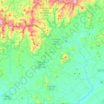
Name: White County topographic map, elevation, terrain.

Location: White County, Georgia, United States (34.50359 -83.87735 34.80137 -83.61559)

Average elevation: 1,824 ft

Minimum elevation: 1,106 ft

Maximum elevation: 4,373 ft

Georgia trails, hiking, mountain biking, running and outdoor activities

Other topographic maps

Click on a map to view its topography, its elevation and its terrain.

Eastanollee

United States > Georgia > Stephens County

Average elevation: 873 ft

Stone Mountain

United States > Georgia > DeKalb County

The park is owned by the state of Georgia and is currently managed by Herschend Family Entertainment. At its summit, the elevation is 1,686 feet (514 m) above sea level and 825 feet (251 m) above the surrounding area. Stone Mountain is well known for not only its geology, but also the enormous rock relief on…

Average elevation: 981 ft

Berkeley Hills

United States > Georgia > Gwinnett County

Average elevation: 958 ft

Lambert Field

United States > Georgia > Coweta County > Newnan

Average elevation: 935 ft

Vinings

United States > Georgia > Cobb County

Vinings features a varied topography characterized by rolling hills and lush, wooded areas that provide a picturesque backdrop to the community. The area is nestled alongside the Chattahoochee River, which contributes to the gentle slopes and valleys that define the landscape. Elevations in Vinings typically…

Average elevation: 922 ft

Big Bald Mountain

United States > Georgia > Gilmer County

Average elevation: 3,350 ft

Hogg Mountain

United States > Georgia > Troup County

Average elevation: 719 ft

Floyd Springs

United States > Georgia > Floyd County

Average elevation: 741 ft

Union

United States > Georgia > Quitman County

Average elevation: 377 ft

Prospect

United States > Georgia > Franklin County

Average elevation: 764 ft

West Hills

United States > Georgia > Richmond County > Augusta

Average elevation: 256 ft

Hayesville Landing

United States > Georgia > Early County

Average elevation: 115 ft

Buffington

United States > Georgia > Cherokee County

Average elevation: 1,076 ft

Sunnyland

United States > Georgia > Dougherty County > Albany

Average elevation: 194 ft

Sand Ridge

United States > Georgia > Richmond County > Augusta

Average elevation: 381 ft

Rockbrook

United States > Georgia > Richmond County > Augusta

Average elevation: 312 ft

Deaton Creek

United States > Georgia > Hall County

Average elevation: 909 ft

Unionville

United States > Georgia > Bibb County > Macon

Average elevation: 433 ft

Lake Dewitt Dam

United States > Georgia > Grady County

Average elevation: 190 ft

Liberty View

United States > Georgia > Bibb County > Macon

Average elevation: 397 ft

Morris

United States > Georgia > Quitman County

Average elevation: 308 ft

Tremont Park

United States > Georgia > Chatham County > Savannah

Average elevation: 23 ft

Chestatee North

United States > Georgia > Hall County

Average elevation: 1,158 ft

Miami Valley

United States > Georgia > Peach County > Fort Valley

Average elevation: 443 ft

DeBruce

United States > Georgia > Richmond County > Augusta

Average elevation: 246 ft

Evergreen

United States > Georgia > Dougherty County > Albany

Average elevation: 197 ft

Aerial

United States > Georgia > Habersham County

Average elevation: 1,476 ft

Wheless

United States > Georgia > Richmond County > Augusta

Average elevation: 285 ft

Ramhurst

United States > Georgia > Murray County

Average elevation: 804 ft

Fort Mountain

United States > Georgia > Murray County

Average elevation: 1,673 ft

Tusculum

United States > Georgia > Effingham County

Average elevation: 115 ft

Cooperville

United States > Georgia > Screven County

Average elevation: 154 ft

Smiths Lake

United States > Georgia > Rockdale County

Average elevation: 807 ft

Rockledge

United States > Georgia > Laurens County

Average elevation: 233 ft

Dyke

United States > Georgia > Gilmer County

Average elevation: 1,667 ft

Emerson Park

United States > Georgia > Ware County

Average elevation: 144 ft

Colony Park

United States > Georgia > Richmond County > Augusta

Average elevation: 302 ft

Highland Circle

United States > Georgia > Bibb County > Macon

Average elevation: 387 ft

Forge Mill

United States > Georgia > Fannin County

Average elevation: 1,762 ft

Mount Rachel

United States > Georgia > Whitfield County > Dalton

Average elevation: 755 ft

Beasley Gap

United States > Georgia > Cherokee County

Average elevation: 1,280 ft

Rabun Gap

United States > Georgia > Rabun County

Average elevation: 2,241 ft

Shellman Bluff

United States > Georgia > McIntosh County

Average elevation: 16 ft

Silver Hill

United States > Georgia > Chattooga County

Average elevation: 869 ft

Whispering Pines

United States > Georgia > Bibb County > Macon

Average elevation: 433 ft

St. Simons

United States > Georgia > Glynn County

Average elevation: 7 ft

Whitesville

United States > Georgia > Harris County

Average elevation: 679 ft

Georgia Island

United States > Georgia > Hall County

Average elevation: 1,089 ft

Bell Knob

United States > Georgia > Towns County

Average elevation: 2,379 ft

Waterloo

United States > Georgia > Irwin County

Average elevation: 331 ft

Driskolls

United States > Georgia > Carroll County > Villa Rica

Average elevation: 1,099 ft

Beverly Heights

United States > Georgia > Richmond County > Augusta

Average elevation: 289 ft

Sargent

United States > Georgia > Coweta County

Average elevation: 810 ft

Dowdell Knob

United States > Georgia > Harris County

Average elevation: 1,056 ft

Bowden

United States > Georgia > Henry County

Average elevation: 830 ft

Dorchester

United States > Georgia > Richmond County > Augusta

Average elevation: 295 ft

Seabrook

United States > Georgia > Liberty County

Average elevation: 23 ft

Newnan Pines

United States > Georgia > Coweta County

Average elevation: 912 ft

Atlanta

United States > Georgia > Fulton County

Atlanta (/ætˈlæntə/ at-LAN-tə) is the capital and most populous city of the U.S. state of Georgia. It is the seat of Fulton County, the most populous county in Georgia. With a population of 498,715 living within the city limits, it is the eighth most populous city in the Southeast and 38th most populous…

Average elevation: 935 ft

Chula

United States > Georgia > Tift County

Average elevation: 361 ft

Settles Bridge

United States > Georgia > Gwinnett County > Suwanee

Average elevation: 1,030 ft

Old Clyattville

United States > Georgia > Lowndes County

Average elevation: 190 ft

Salem

United States > Georgia > Richmond County > Augusta

Average elevation: 299 ft

Pleasant Hill

United States > Georgia > Fannin County

Average elevation: 1,795 ft

Moncrief

United States > Georgia > Grady County

Average elevation: 217 ft

Mauk

United States > Georgia > Taylor County

Average elevation: 719 ft

Elko

United States > Georgia > Houston County

Average elevation: 404 ft

Blood Mountain

United States > Georgia > Union County

Blood Mountain is the highest peak on the Georgia section of the Appalachian Trail and the sixth-tallest mountain in Georgia, with an elevation of 4,458 feet (1,359 m). It is located on the border of Lumpkin County with Union County and is within the boundaries of the Chattahoochee National Forest and the…

Average elevation: 3,438 ft

Sea Island

United States > Georgia > Glynn County

Average elevation: 7 ft

McCullough

United States > Georgia > Fannin County

Average elevation: 1,834 ft

Shoal Creek

United States > Georgia > Clarke County > Athens

Average elevation: 738 ft

Springlake Estates

United States > Georgia > Gwinnett County > Buford

Average elevation: 1,158 ft

Blowing Spring

United States > Georgia > Walker County

Average elevation: 1,063 ft

Lax

United States > Georgia > Coffee County

Average elevation: 279 ft

Dawson Heights

United States > Georgia > Dougherty County > Albany

Average elevation: 236 ft

Bobo

United States > Georgia > Gordon County

Average elevation: 912 ft

Union

United States > Georgia > Henry County

Average elevation: 705 ft

Strickland Heights

United States > Georgia > Hall County

Average elevation: 1,066 ft

St. Simons

United States > Georgia > Glynn County

Average elevation: 7 ft

Lake Lure Dam

United States > Georgia > Bacon County > Alma

Average elevation: 194 ft

Mineral Bluff

United States > Georgia > Fannin County

Average elevation: 1,693 ft

Texas

United States > Georgia > Heard County

Average elevation: 846 ft

Box Springs

United States > Georgia > Talbot County

Average elevation: 407 ft

Villanow

United States > Georgia > Walker County

Average elevation: 925 ft

Windsor Court

United States > Georgia > Richmond County > Augusta

Average elevation: 217 ft

Brook Run Park

United States > Georgia > DeKalb County > Dunwoody

Average elevation: 1,001 ft

Mountain Park

United States > Georgia > Gwinnett County

Average elevation: 958 ft

Lake Joy

United States > Georgia > Houston County

Average elevation: 344 ft

Saint Simons

United States > Georgia > Glynn County

Average elevation: 7 ft