Geolocate

Fanshawe topographic map

Click on the map to display elevation.

About this map

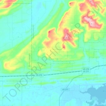
Name: Fanshawe topographic map, elevation, terrain.

Location: Fanshawe, Le Flore County, Oklahoma, 74935, United States (34.93035 -94.95376 35.03772 -94.75998)

Average elevation: 689 ft

Minimum elevation: 479 ft

Maximum elevation: 1,503 ft

Le Flore County trails, hiking, mountain biking, running and outdoor activities

Other topographic maps

Click on a map to view its topography, its elevation and its terrain.

Tombstone Mountain

United States > Oklahoma > Le Flore County

Average elevation: 1,496 ft

Trestle Ford

United States > Oklahoma > Le Flore County

Average elevation: 614 ft

Big Cedar

United States > Oklahoma > Le Flore County

Average elevation: 1,001 ft

Page

United States > Oklahoma > Le Flore County

Average elevation: 1,273 ft

Harvey Mountain

United States > Oklahoma > Le Flore County

Average elevation: 906 ft

Sunset Corner

United States > Oklahoma > Le Flore County

Average elevation: 482 ft

Octavia

United States > Oklahoma > Le Flore County > Octavia

Average elevation: 935 ft

Gear up for your next adventure:

📖Nature Tracking Books - Learn to track wildlife and terrain
📦Dry Bags Set - Waterproof storage for electronics and clothes
🦟Ultrasonic Repellers - Create a bug-free zone at your camp or rest stop
🪶Wildlife Field Guides - Learn animal tracking and species ID
🥾Men's Hiking Boots - Durable, waterproof footwear for rugged terrain and steep inclines

As an Amazon Associate, this site earns from qualifying purchases at no extra cost to you.