
Make a donation
Gear up for your next adventure:
As an Amazon Associate, this site earns from qualifying purchases at no extra cost to you.
Dobra topographic map
Click on the map to display elevation.
Make a donation
Gear up for your next adventure:
As an Amazon Associate, this site earns from qualifying purchases at no extra cost to you.
About this map
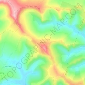
Name: Dobra topographic map, elevation, terrain.
Location: Dobra, Papiu Ilarian, Mureș, 547446, Romania (46.56142 24.21735 46.60142 24.25735)
Average elevation: 1,253 ft
Minimum elevation: 1,017 ft
Maximum elevation: 1,591 ft
Make a donation
Gear up for your next adventure:
As an Amazon Associate, this site earns from qualifying purchases at no extra cost to you.
Other topographic maps
Click on a map to view its topography, its elevation and its terrain.
Târgu Mureș
The old City Hall was built in 1906–1907 after the construction plans of Márcell Komor and Dezső Jakab. The entrance area, including the corridor and the staircase leading to the first floor, is the most representative in this regard. The ribbed stellar vaults that cover this area were inspired by Gothic…
Average elevation: 1,171 ft
Make a donation
Gear up for your next adventure:
As an Amazon Associate, this site earns from qualifying purchases at no extra cost to you.
Bichiș
The commune is situated on the Transylvanian Plateau, at an altitude of 338 m (1,109 ft), on the banks of the river Ațintiș. It is located in the southwestern part of Mureș County, 16 km (10 mi) south of the town of Luduș and 53 km (33 mi) from the county seat, Târgu Mureș, on the border with Alba County.
Average elevation: 1,296 ft
Make a donation
Gear up for your next adventure:
As an Amazon Associate, this site earns from qualifying purchases at no extra cost to you.
Make a donation
Gear up for your next adventure:
As an Amazon Associate, this site earns from qualifying purchases at no extra cost to you.
Make a donation
Gear up for your next adventure:
As an Amazon Associate, this site earns from qualifying purchases at no extra cost to you.
Make a donation
Gear up for your next adventure:
As an Amazon Associate, this site earns from qualifying purchases at no extra cost to you.
Make a donation
Gear up for your next adventure:
As an Amazon Associate, this site earns from qualifying purchases at no extra cost to you.
Make a donation
Gear up for your next adventure:
As an Amazon Associate, this site earns from qualifying purchases at no extra cost to you.
Make a donation
Gear up for your next adventure:
As an Amazon Associate, this site earns from qualifying purchases at no extra cost to you.
Târgu Mureș
The old City Hall was built in 1906–1907 after the construction plans of Márcell Komor and Dezső Jakab. The entrance area, including the corridor and the staircase leading to the first floor, is the most representative in this regard. The ribbed stellar vaults that cover this area were inspired by Gothic…
Average elevation: 1,171 ft
Make a donation
Gear up for your next adventure:
As an Amazon Associate, this site earns from qualifying purchases at no extra cost to you.
Make a donation
Gear up for your next adventure:
As an Amazon Associate, this site earns from qualifying purchases at no extra cost to you.