Geolocate

Penipe topographic map

Click on the map to display elevation.

About this map

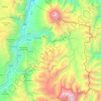
Name: Penipe topographic map, elevation, terrain.

Location: Penipe, Chimborazo, Ecuador (-1.67466 -78.54872 -1.43396 -78.35854)

Average elevation: 10,896 ft

Minimum elevation: 7,083 ft

Maximum elevation: 16,969 ft

Other topographic maps

Click on a map to view its topography, its elevation and its terrain.

Santa Cruz

Ecuador > Chimborazo > Riobamba > Riobamba

Average elevation: 9,114 ft

Navac

Ecuador > Chimborazo > Colta > Columbe

Average elevation: 5,820 ft

Pulucate

Ecuador > Chimborazo > Colta > Columbe

Average elevation: 10,965 ft

Palmira

Ecuador > Chimborazo > Alausí > Achupallas

Average elevation: 9,820 ft

Gear up for your next adventure:

🪄Magnetic Compass - Accurate compass for navigation
🪶Camping Sleeping Pad - Comfortable sleeping pad for backpacking
🏥Hiking First Aid Kits - Comprehensive medical kits for remote trail injuries
🏔️Mountain Trail Maps - High‑detail maps for popular peaks
🪵Folding Camp Saw - Compact saw for wood and campsite work

As an Amazon Associate, this site earns from qualifying purchases at no extra cost to you.