
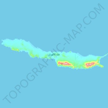
عبد الكوري topographic map
Interactive map
Click on the map to display elevation.
About this map
Name: عبد الكوري topographic map, elevation, terrain.
Average elevation: 23 ft
Minimum elevation: -3 ft
Maximum elevation: 1,844 ft
Much of Abd al Kuri is semi-desert with little vegetation. Two ranges of hills separated near the centre occupy the entire length of the island. The northern coast consists mostly of a sandy beach with a few rocky points, while the southern coast consists of steep cliffs. Its highest point, Mount Ṣāliḥ, reaches an altitude of over 700 metres (2,300 feet). Most of its inhabitants subsist on fishing. Kilmia is the main village.
Other topographic maps
Click on a map to view its topography, its elevation and its terrain.