
Make a donation
Gear up for your next adventure:
As an Amazon Associate, this site earns from qualifying purchases at no extra cost to you.
Mutrah topographic map
Click on the map to display elevation.
Make a donation
Gear up for your next adventure:
As an Amazon Associate, this site earns from qualifying purchases at no extra cost to you.
About this map
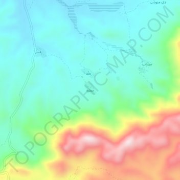
Name: Mutrah topographic map, elevation, terrain.
Location: Mutrah, Hidaybu District, Socotra Governorate, Yemen (12.54303 54.23276 12.58303 54.27276)
Average elevation: 715 ft
Minimum elevation: 180 ft
Maximum elevation: 1,929 ft
Make a donation
Gear up for your next adventure:
As an Amazon Associate, this site earns from qualifying purchases at no extra cost to you.
Other topographic maps
Click on a map to view its topography, its elevation and its terrain.
عبد الكوري
Much of Abd al Kuri is semi-desert with little vegetation. Two ranges of hills separated near the centre occupy the entire length of the island. The northern coast consists mostly of a sandy beach with a few rocky points, while the southern coast consists of steep cliffs. Its highest point, Mount Ṣāliḥ,…
Average elevation: 23 ft