Geolocate

Gigaquit topographic map

Click on the map to display elevation.

About this map

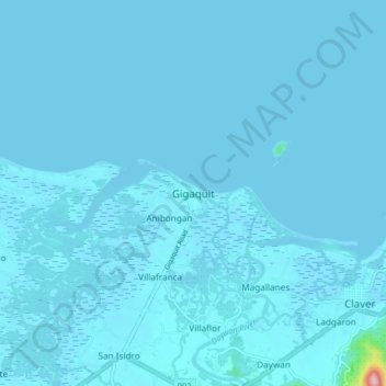
Name: Gigaquit topographic map, elevation, terrain.

Location: Gigaquit, Surigao del Norte, Caraga, Philippines (9.55582 125.65764 9.63582 125.73764)

Average elevation: 13 ft

Minimum elevation: -7 ft

Maximum elevation: 656 ft

Other topographic maps

Click on a map to view its topography, its elevation and its terrain.

Siargao

Philippines > Surigao Del Norte

Average elevation: 36 ft

Mayag River

Philippines > Surigao Del Norte > Cantugas

Average elevation: 597 ft

Burgos

Philippines > Surigao Del Norte

Average elevation: 98 ft

Alegria

Philippines > Surigao Del Norte

Average elevation: 709 ft

San Isidro

Philippines > Surigao Del Norte > San Isidro

Average elevation: 89 ft

Gear up for your next adventure:

🔋Solar Power Banks - Keep your GPS and phone charged in remote wilderness areas
🔭Stargazing Telescopes - Perfect for camping in low-light pollution areas shown on maps
🛰️Satellite Messengers - Emergency SOS and two-way messaging for off-grid adventures
🔦Compact Flashlight - Reliable flashlight for emergencies
🥘Titanium Cookware - Durable, featherlight pots and pans for backpacking

As an Amazon Associate, this site earns from qualifying purchases at no extra cost to you.