Geolocate

Burgos topographic map

Click on the map to display elevation.

About this map

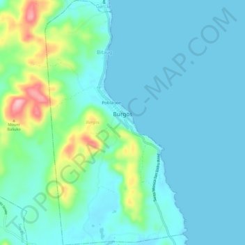
Name: Burgos topographic map, elevation, terrain.

Location: Burgos, Surigao del Norte, Caraga, 8424, Philippines (9.98927 126.05694 10.04309 126.08863)

Average elevation: 98 ft

Minimum elevation: -3 ft

Maximum elevation: 535 ft

Other topographic maps

Click on a map to view its topography, its elevation and its terrain.

Corregidor

Philippines > Surigao Del Norte > Dapa > Dapa

Average elevation: 7 ft

Pangi

Philippines > Surigao Del Norte > Del Carmen

Average elevation: 75 ft

Mayag River

Philippines > Surigao Del Norte > Cantugas

Average elevation: 597 ft

Mainit

Philippines > Surigao Del Norte

Average elevation: 269 ft

Gigaquit

Philippines > Surigao Del Norte

Average elevation: 13 ft

Luna

Philippines > Surigao Del Norte

Average elevation: 121 ft

Sukailang

Philippines > Surigao Del Norte

Average elevation: 157 ft

Ima

Philippines > Surigao Del Norte

Average elevation: 335 ft

Rizal

Philippines > Surigao Del Norte > Socorro

Average elevation: 131 ft

Gear up for your next adventure:

💧Water Purification System - Clean water on the trail with reliable purifiers
📶Satellite Messenger - Communication device off‑grid
🪶Thermal Camp Blanket - Extra warmth for cold nights
🧭Compass with Lanyard - Easy‑carry compass for navigation
🧢Sun Protection Hats - Wide-brimmed and UPF-rated hats for high-altitude sun safety

As an Amazon Associate, this site earns from qualifying purchases at no extra cost to you.