
Make a donation
Gear up for your next adventure:
As an Amazon Associate, this site earns from qualifying purchases at no extra cost to you.
Cheakamus River topographic map
Click on the map to display elevation.
Make a donation
Gear up for your next adventure:
As an Amazon Associate, this site earns from qualifying purchases at no extra cost to you.
About this map
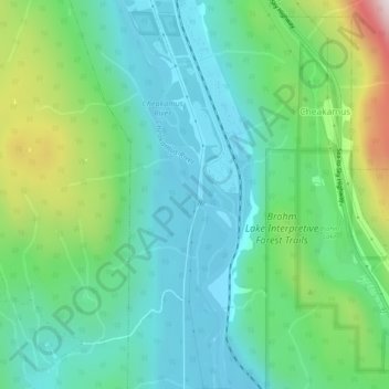
Name: Cheakamus River topographic map, elevation, terrain.
Average elevation: 873 ft
Minimum elevation: 161 ft
Maximum elevation: 2,884 ft
Make a donation
Gear up for your next adventure:
As an Amazon Associate, this site earns from qualifying purchases at no extra cost to you.
Other topographic maps
Click on a map to view its topography, its elevation and its terrain.
Stawamus Chief Provincial Park
Canada > British Columbia > Squamish-Lillooet Regional District > Squamish
Average elevation: 1,421 ft
Watts Point
Canada > British Columbia > Squamish-Lillooet Regional District > Squamish
Average elevation: 144 ft
The Galapagos Islands Boulder
Canada > British Columbia > Squamish-Lillooet Regional District > Squamish
Average elevation: 948 ft
The Galapagos Islands Boulder
Canada > British Columbia > Squamish-Lillooet Regional District > Squamish
Average elevation: 948 ft
Make a donation
Gear up for your next adventure:
As an Amazon Associate, this site earns from qualifying purchases at no extra cost to you.