
Watts Point topographic map
Click on the map to display elevation.
About this map
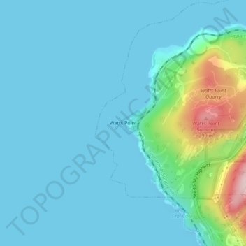
Name: Watts Point topographic map, elevation, terrain.
Average elevation: 144 ft
Minimum elevation: 0 ft
Maximum elevation: 1,004 ft
Other topographic maps
Click on a map to view its topography, its elevation and its terrain.
Stawamus Chief Provincial Park
Canada > British Columbia > Squamish-Lillooet Regional District > Squamish
Average elevation: 1,421 ft
Edith Lake
Canada > British Columbia > Squamish-Lillooet Regional District > Squamish
Average elevation: 1,014 ft
Alice Lake
Canada > British Columbia > Squamish-Lillooet Regional District > Squamish
Average elevation: 810 ft
Cheakamus River
Canada > British Columbia > Squamish-Lillooet Regional District > Squamish
Average elevation: 873 ft