Geolocate

Efrat topographic map

Click on the map to display elevation.

Efrat

Efrat (Hebrew: אֶפְרָת), or previously officially Efrata (Hebrew: אֶפְרָתָה), is an Israeli settlement in the West Bank, established in 1983 in the Judean Mountains. Efrat is located 12 kilometers (7.5 mi) south of Jerusalem, between Bethlehem and Hebron, 6.5 km (4 mi) east of the Green Line, at the Palestinian side of the West Bank wall. The settlement stands at an altitude of up to 960 metres (3,150 feet) above sea level and covers about 6,000 dunam (1,500 acres). The international community considers Israeli settlements in the West Bank illegal under international law, but the Israeli government disputes this.

Wikipedia (CC-BY-SA 3.0)

About this map

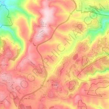
Name: Efrat topographic map, elevation, terrain.

Location: Efrat, Area C, Judea and Samaria, Palestinian Territory (31.64648 35.14319 31.68911 35.20246)

Average elevation: 2,887 ft

Minimum elevation: 2,113 ft

Maximum elevation: 3,268 ft

Other topographic maps

Click on a map to view its topography, its elevation and its terrain.

Barkan

Palestinian Territory > Judea and Samaria > Area C

Average elevation: 1,342 ft

Yitzhar

Palestinian Territory > Judea and Samaria > Area C

Average elevation: 2,093 ft

Alon Shvut

Palestinian Territory > Judea and Samaria > Area C

Average elevation: 3,022 ft

Meitzad

Palestinian Territory > Judea and Samaria > Area C

Average elevation: 2,838 ft

Gitit

Palestinian Territory > Judea and Samaria > Area C

Average elevation: 823 ft

Rimonim

Palestinian Territory > Judea and Samaria > Area C

Average elevation: 1,942 ft

Bat Ayin

Palestinian Territory > Judea and Samaria > Area C

Average elevation: 2,671 ft

Hermesh

Palestinian Territory > Judea and Samaria > Area C

Average elevation: 682 ft

HaRoeh

Palestinian Territory > Judea and Samaria > Area C > Eli

Average elevation: 2,228 ft

Keidar

Palestinian Territory > Judea and Samaria > Area C

Average elevation: 1,394 ft

Gear up for your next adventure:

🥾Hiking Shoes - Durable and comfortable shoes for trail hiking
🔭Stargazing Telescopes - Perfect for camping in low-light pollution areas shown on maps
🪑Portable Camp Table - Compact table for campsite meals
🏫Relief Map Kits - Hands-on tools for teaching landforms and elevation
👓Polarized Sunglasses - Outdoor sunglasses for glare reduction

As an Amazon Associate, this site earns from qualifying purchases at no extra cost to you.