
Barkan topographic map
Click on the map to display elevation.
About this map
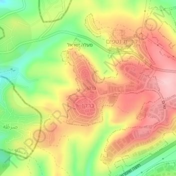
Name: Barkan topographic map, elevation, terrain.
Location: Barkan, Area C, Judea and Samaria, Palestinian Territory (32.10361 35.10241 32.11495 35.11022)
Average elevation: 1,342 ft
Minimum elevation: 1,014 ft
Maximum elevation: 1,601 ft
Other topographic maps
Click on a map to view its topography, its elevation and its terrain.
Dead Sea
Palestinian Territory > Judea and Samaria > Area C
The lake's surface is 430.5 metres (1,412 ft) below sea level, making its shores the lowest land-based elevation on Earth. It is 304 m (997 ft) deep, the deepest hypersaline lake in the world. With a salinity of 342 g/kg, or 34.2% (in 2011), it is one of the world's saltiest bodies of water – 9.6 times as…
Average elevation: 331 ft
Efrat
Palestinian Territory > Judea and Samaria > Area C
Efrat (Hebrew: אֶפְרָת), or previously officially Efrata (Hebrew: אֶפְרָתָה), is an Israeli settlement in the West Bank, established in 1983 in the Judean Mountains. Efrat is located 12 kilometers (7.5 mi) south of Jerusalem, between Bethlehem and Hebron, 6.5 km (4 mi) east of the Green Line,…
Average elevation: 2,887 ft
Khirbet an Nahla
Palestinian Territory > Judea and Samaria > Area C > Wadi Rahhal > Khirbet an Nahla
Average elevation: 2,625 ft