
Make a donation
Gear up for your next adventure:
As an Amazon Associate, this site earns from qualifying purchases at no extra cost to you.
Alon Shvut topographic map
Click on the map to display elevation.
Make a donation
Gear up for your next adventure:
As an Amazon Associate, this site earns from qualifying purchases at no extra cost to you.
About this map
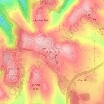
Name: Alon Shvut topographic map, elevation, terrain.
Location: Alon Shvut, Area C, Judea and Samaria, Palestinian Territory (31.65007 35.12171 31.65938 35.12914)
Average elevation: 3,022 ft
Minimum elevation: 2,595 ft
Maximum elevation: 3,186 ft
Make a donation
Gear up for your next adventure:
As an Amazon Associate, this site earns from qualifying purchases at no extra cost to you.
Other topographic maps
Click on a map to view its topography, its elevation and its terrain.
Dead Sea
Palestinian Territory > Judea and Samaria > Area C
The lake's surface is 430.5 metres (1,412 ft) below sea level, making its shores the lowest land-based elevation on Earth. It is 304 m (997 ft) deep, the deepest hypersaline lake in the world. With a salinity of 342 g/kg, or 34.2% (in 2011), it is one of the world's saltiest bodies of water – 9.6 times as…
Average elevation: 331 ft
Efrat
Palestinian Territory > Judea and Samaria > Area C
Efrat (Hebrew: אֶפְרָת), or previously officially Efrata (Hebrew: אֶפְרָתָה), is an Israeli settlement in the West Bank, established in 1983 in the Judean Mountains. Efrat is located 12 kilometers (7.5 mi) south of Jerusalem, between Bethlehem and Hebron, 6.5 km (4 mi) east of the Green Line,…
Average elevation: 2,887 ft
Make a donation
Gear up for your next adventure:
As an Amazon Associate, this site earns from qualifying purchases at no extra cost to you.
Khirbet an Nahla
Palestinian Territory > Judea and Samaria > Area C > Wadi Rahhal > Khirbet an Nahla
Average elevation: 2,625 ft