
Denpasar topographic map
Click on the map to display elevation.
Denpasar
Denpasar is located at an elevation of 4 m (13 ft) above sea level. While the total area of 125.98 km2 or 2.18% of the total area of Bali Province. From the use of land, 2,768 hectares of land are paddy, 10,001 hectares are dry land, while the remaining land area is 9 hectares.
About this map
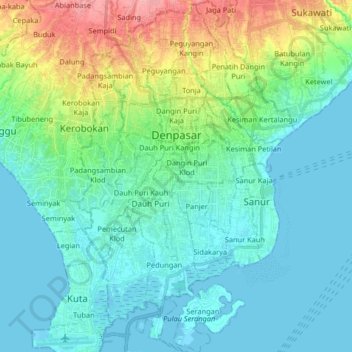
Name: Denpasar topographic map, elevation, terrain.
Location: Denpasar, Bali, Lesser Sunda Islands, Indonesia (-9.03749 115.17319 -8.59084 115.45215)
Average elevation: 23 ft
Minimum elevation: -3 ft
Maximum elevation: 679 ft
Other topographic maps
Click on a map to view its topography, its elevation and its terrain.
CitraLand Waterpark Denpasar
Indonesia > Bali > Denpasar > Denpasar Barat > Padangsambian Kaja
Average elevation: 184 ft
Point of view on the lake and the mount Batur
Indonesia > Bali > Bangli > Songan B
Average elevation: 3,474 ft
Mount Agung
Indonesia > Bali > Karangasem
Australia's Bureau of Meteorology reported on 27 November that ash from the eruption had been observed at an altitude of 9,144 m. By the beginning of December, the eruption reduced to minor emissions of steam and smoke. On 12 December, a picture of the crater was taken showing a steadily growing lava dome…
Average elevation: 8,314 ft