
Aldie topographic map
Click on the map to display elevation.
About this map
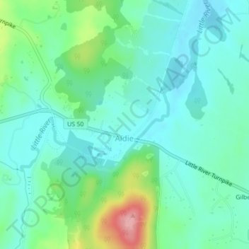
Name: Aldie topographic map, elevation, terrain.
Location: Aldie, Loudoun County, Virginia, United States (38.97292 -77.65078 38.98103 -77.63838)
Average elevation: 390 ft
Minimum elevation: 289 ft
Maximum elevation: 699 ft
Other topographic maps
Click on a map to view its topography, its elevation and its terrain.
Ashburn
United States > Virginia > Loudoun County > Ashburn
Ashburn is located at 39°02′37″N 077°29′15″W / 39.04361°N 77.48750°W / 39.04361; -77.48750 (39.0437192, −77.4874899) and its average elevation is 295 feet (90 m) above sea level. According to the 2010 United States Census, the CDP has a total area of 17.287 square miles (44.77 km2), of…
Average elevation: 282 ft
Leesburg
United States > Virginia > Loudoun County
Leesburg is located northeast of the center of Loudoun County at 39°7′N 77°33′W / 39.117°N 77.550°W / 39.117; -77.550 (39.109, −77.558), It is part of the northern Virginia Piedmont and sits at the base of the easternmost chain of the Blue Ridge Mountains, Catoctin Mountain. The town lies in…
Average elevation: 371 ft
Sterling
United States > Virginia > Loudoun County > Sterling
According to the USGS, Sterling has an average elevation of 289 feet (88 m) above sea level. The original center of Sterling is located at 39°00'22.4"N 77°25'43.0"W. Sterling is part of the Chesapeake Bay watershed, and Greater Sterling borders the Potomac River.
Average elevation: 318 ft
Leesburg
United States > Virginia > Loudoun County
Leesburg is located northeast of the center of Loudoun County at 39°7′N 77°33′W / 39.117°N 77.550°W / 39.117; -77.550 (39.109, −77.558), It is part of the northern Virginia Piedmont and sits at the base of the easternmost chain of the Blue Ridge Mountains, Catoctin Mountain. The town lies in…
Average elevation: 371 ft
Loudoun Valley Estates
United States > Virginia > Loudoun County
The land around Loudoun Valley Estates is gently rolling. The average elevation is 289 feet (88 m). The population density is about 500 people per square kilometer.
Average elevation: 299 ft
Middleburg
United States > Virginia > Loudoun County
According to the United States Census Bureau, the town has a total area of 0.6 square mile (1.5 km2), all land. The elevation is 486 feet.
Average elevation: 469 ft
Paris Mountain
United States > Virginia > Loudoun County
Paris Mountain is a peak of Blue Ridge Mountain on the border of Loudoun County and Clarke County in Virginia. The 1,926 feet (587 m) peak, which is located just north of Ashby's Gap and the town of Paris, for which it is named, represents the highest elevation in both counties. The peak is accessible by Blue…
Average elevation: 1,483 ft
Leesburg
United States > Virginia > Loudoun County
Leesburg is located northeast of the center of Loudoun County, Virginia, at 39°6′56″N 77°33′52″W / 39.11556°N 77.56444°W / 39.11556; -77.56444 (39.1155, −77.5644), It is part of the northern Virginia Piedmont and sits at the base of the easternmost chain of the Blue Ridge Mountains,…
Average elevation: 371 ft
Middleburg
United States > Virginia > Loudoun County
According to the United States Census Bureau, the town has a total area of 0.6 square mile (1.5 km2), all land. The elevation is 486 feet.
Average elevation: 469 ft
Middleburg
United States > Virginia > Loudoun County
According to the United States Census Bureau, the town has a total area of 0.6 square mile (1.5 km2), all land. The elevation is 486 feet.
Average elevation: 469 ft
Ashburn
United States > Virginia > Loudoun County > Ashburn
Ashburn is located in eastern Loudoun County at 39°02′37″N 077°29′15″W / 39.04361°N 77.48750°W / 39.04361; -77.48750 (39.0437192, −77.4874899) and its average elevation is 295 feet (90 m) above sea level. It is 7 miles (11 km) southeast of Leesburg, the county seat, and the same distance…
Average elevation: 282 ft
Middleburg
United States > Virginia > Loudoun County
According to the United States Census Bureau, the town has a total area of 0.6 square mile (1.5 km2), all land. The elevation is 486 feet.
Average elevation: 469 ft
Sterling
United States > Virginia > Loudoun County
According to the USGS, Sterling has an average elevation of 289 feet (88 m) above sea level. The original center of Sterling is located at 39°00'22.4"N 77°25'43.0"W. Sterling is part of the Chesapeake Bay watershed, and Greater Sterling borders the Potomac River.
Average elevation: 318 ft
Ashburn
United States > Virginia > Loudoun County > Ashburn
Ashburn is located in eastern Loudoun County at 39°02′37″N 077°29′15″W / 39.04361°N 77.48750°W / 39.04361; -77.48750 (39.0437192, −77.4874899) and its average elevation is 295 feet (90 m) above sea level. It is 7 miles (11 km) southeast of Leesburg, the county seat, and the same distance…
Average elevation: 282 ft