Geolocate

Townshend topographic map

Click on the map to display elevation.

About this map

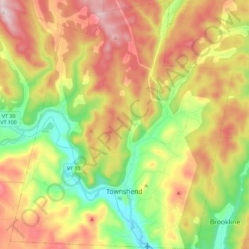
Name: Townshend topographic map, elevation, terrain.

Location: Townshend, Windham County, Vermont, 05353, United States (43.01840 -72.74329 43.13786 -72.59618)

Average elevation: 1,214 ft

Minimum elevation: 387 ft

Maximum elevation: 2,162 ft

Other topographic maps

Click on a map to view its topography, its elevation and its terrain.

Guilford Center

United States > Vermont > Windham County > Guilford

Average elevation: 866 ft

Sherwood Forest

United States > Vermont > Windham County > Londonderry

Average elevation: 1,371 ft

North Windham

United States > Vermont > Windham County > Londonderry

Average elevation: 1,699 ft

West Guilford

United States > Vermont > Windham County > Guilford

Average elevation: 1,129 ft

East Dover

United States > Vermont > Windham County > Dover

Average elevation: 1,394 ft

East Dover

United States > Vermont > Windham County > Dover

Average elevation: 1,394 ft

Kenny Pond Dam

United States > Vermont > Windham County > Newfane

Average elevation: 1,355 ft

West Dover

United States > Vermont > Windham County > Dover

Average elevation: 1,913 ft

South Newfane

United States > Vermont > Windham County > Newfane

Average elevation: 1,053 ft

Mount Snow

United States > Vermont > Windham County

Average elevation: 2,838 ft

Packer Corner

United States > Vermont > Windham County > Guilford

Average elevation: 1,001 ft

Mount Snow

United States > Vermont > Windham County

Average elevation: 2,835 ft

West Townshend

United States > Vermont > Windham County > Townshend

Average elevation: 968 ft

Sherwood Forest

United States > Vermont > Windham County > Londonderry

Average elevation: 1,371 ft

Stratton Mountain

United States > Vermont > Windham County > Stratton

Average elevation: 3,268 ft

Williamsville

United States > Vermont > Windham County > Newfane

Average elevation: 886 ft

Wilmington

United States > Vermont > Windham County > Wilmington > Wilmington

Wilmington experiences a humid continental climate (Koppen Dfb) with warm, humid summers and cold (sometimes severely cold) winters. While snowfall can vary greatly from year to year in nearby towns like Bennington and Brattleboro, Wilmington's snowfall is consistently heavy each year because of its elevation…

Average elevation: 1,690 ft

Gear up for your next adventure:

🔥Fast-Boil Camping Stoves - Efficient cooking systems for quick trail meals
🔪Outdoor Multitools - Essential survival tools for gear repair and field use
🧴Hand Sanitizer - Keep hands clean while hiking
🖼️Topo Map Wall Art - Decorative topographic prints of famous peaks and regions
🔊Portable Camp Speaker - Music and alerts at camp

As an Amazon Associate, this site earns from qualifying purchases at no extra cost to you.