
Mojave topographic map
Interactive map
Click on the map to display elevation.
About this map
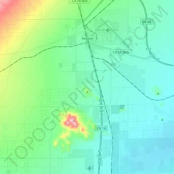
Name: Mojave topographic map, elevation, terrain.
Location: Mojave, Kern County, California, United States (34.93736 -118.25786 35.08440 -118.10427)
Average elevation: 2,877 ft
Minimum elevation: 2,507 ft
Maximum elevation: 4,593 ft
Mojave (formerly Mohave) is an unincorporated community in Kern County, California, United States. Mojave is located 50 miles (80 km) east of Bakersfield, and 100 miles (161 km) north of Los Angeles, at an elevation of 2,762 feet (842 m). The town is located in the western region of the Mojave Desert, below and east of Oak Creek Pass and the Tehachapi Mountains. Mojave is on the Pacific Crest Trail.
Other topographic maps
Click on a map to view its topography, its elevation and its terrain.
Bakersfield
United States > California > Kern County
Bakersfield, Kern County, California, United States
Average elevation: 515 ft
Bear Valley Springs
United States > California > Kern County
Bear Valley Springs, Kern County, California, United States
Average elevation: 3,950 ft
Millersville
United States > California > Kern County
Millersville, Kern County, California, United States
Average elevation: 3,163 ft
Ridgecrest
United States > California > Kern County
Ridgecrest, Kern County, California, 93555, United States
Average elevation: 2,425 ft
Weldon
United States > California > Kern County
Weldon, Kern County, California, 93283, United States
Average elevation: 3,379 ft
Frazier Park
United States > California > Kern County
Frazier Park, Kern County, California, United States
Average elevation: 5,030 ft
Fellows
United States > California > Kern County
Fellows, Kern County, California, United States
Average elevation: 1,378 ft
Potomac County Park
United States > California > Kern County
Potomac County Park, Kern County, California, United States
Average elevation: 427 ft
East Bakersfield
United States > California > Kern County
East Bakersfield, Kern County, California, 93305, United States
Average elevation: 518 ft
Hillcrest Point
United States > California > Kern County
Hillcrest Point, Kern County, California, United States
Average elevation: 1,348 ft
Rosedale
United States > California > Kern County
Rosedale, Kern County, California, United States
Average elevation: 371 ft
Shafter
United States > California > Kern County
Shafter, Kern County, California, 93253, United States
Average elevation: 354 ft
South Taft
United States > California > Kern County > Taft > South Taft
South Taft, Taft, Kern County, California, United States
Average elevation: 1,125 ft
Kernville
United States > California > Kern County
Kernville, Kern County, California, 93238, United States
Average elevation: 3,724 ft
Ford City
United States > California > Kern County > Taft
Ford City, Taft, Kern County, California, United States
Average elevation: 866 ft
Buttonwillow
United States > California > Kern County
Buttonwillow, Kern County, California, 93206, United States
Average elevation: 285 ft
Shirley Meadows
United States > California > Kern County
Shirley Meadows, Kern County, California, United States
Average elevation: 6,063 ft
Bakersfield
United States > California > Kern County > Bakersfield
Bakersfield, Kern County, California, 93301, United States
Average elevation: 528 ft
Blue Moon Ranch
United States > California > Kern County
Blue Moon Ranch, Kern County, California, United States
Average elevation: 253 ft
Lost Hills
United States > California > Kern County
Lost Hills, Kern County, California, 93249, United States
Average elevation: 269 ft
Lokern
United States > California > Kern County
Lokern, Kern County, California, United States
Average elevation: 292 ft
Brown
United States > California > Kern County
Brown, Kern County, California, United States
Average elevation: 2,402 ft
Bodfish
United States > California > Kern County
Bodfish, Kern County, California, 93205, United States
Average elevation: 2,943 ft
Lebec
United States > California > Kern County
Lebec, Kern County, California, 93243, United States
Average elevation: 3,812 ft
Quailwood
United States > California > Kern County > Bakersfield
Quailwood, Bakersfield, Kern County, CAL Fire Southern Region, California, 93309, United States
Average elevation: 390 ft
Rancho Seco
United States > California > Kern County
Rancho Seco, Kern County, California, United States
Average elevation: 2,044 ft
Stallion Springs
United States > California > Kern County > Stallion Springs
Stallion Springs, Kern County, California, United States
Average elevation: 3,927 ft
Brite Lake Recreational Park
United States > California > Kern County
Brite Lake Recreational Park, Kern County, California, United States
Average elevation: 4,442 ft
Oildale
United States > California > Kern County
Oildale, Kern County, California, United States
Average elevation: 538 ft
Shafter
United States > California > Kern County
Shafter, City of Shafter, Kern County, CAL Fire Southern Region, California, United States
Average elevation: 394 ft
California City
United States > California > Kern County
California City, Kern County, California, United States
Average elevation: 2,772 ft
Wofford Heights
United States > California > Kern County
Wofford Heights, Kern County, California, 93285, United States
Average elevation: 3,655 ft
Rosedale
United States > California > Kern County
Rosedale, Kern County, CAL Fire Contract Counties, California, United States
Average elevation: 351 ft
Greenfield
United States > California > Kern County
Greenfield, Kern County, California, United States
Average elevation: 348 ft
Twin Oaks
United States > California > Kern County
Twin Oaks, Kern County, California, United States
Average elevation: 3,100 ft
Delano
United States > California > Kern County
Delano, Kern County, California, 93215, United States
Average elevation: 325 ft
Keene
United States > California > Kern County
Keene, Kern County, California, 93531, United States
Average elevation: 2,927 ft
Golden Hills
United States > California > Kern County
Golden Hills, Kern County, California, 93561, United States
Average elevation: 4,183 ft
Grapevine
United States > California > Kern County
Grapevine, Kern County, California, United States
Average elevation: 1,644 ft
Sand Canyon
United States > California > Kern County
Sand Canyon, Kern County, California, United States
Average elevation: 3,071 ft
Taft Heights
United States > California > Kern County > Taft > Taft Heights
Taft Heights, Taft, Kern County, California, United States
Average elevation: 1,207 ft
Smith Corner
United States > California > Kern County
Smith Corner, Kern County, CAL Fire Southern Region, California, 93263, United States
Average elevation: 338 ft
Inyokern
United States > California > Kern County
Inyokern, Kern County, California, United States
Average elevation: 2,470 ft
City of Bakersfield
United States > California > Kern County
City of Bakersfield, Kern County, California, 93304, United States
Average elevation: 394 ft
Pine Mountain Club
United States > California > Kern County
Pine Mountain Club, Kern County, CAL Fire Southern Region, California, 93222, United States
Average elevation: 6,125 ft
Taft
United States > California > Kern County
Taft, Kern County, California, 93268, United States
Average elevation: 1,214 ft
Old River
United States > California > Kern County
Old River, Kern County, California, United States
Average elevation: 338 ft
Rosamond
United States > California > Kern County
Rosamond, Kern County, California, 93560, United States
Average elevation: 2,457 ft
Woodford
United States > California > Kern County
Woodford, El Rita, Kern County, California, United States
Average elevation: 2,949 ft
Baker
United States > California > Kern County > Boron
Baker, Boron, Kern County, California, United States
Average elevation: 2,510 ft