
Make a donation
Gear up for your next adventure:
As an Amazon Associate, this site earns from qualifying purchases at no extra cost to you.
Lunca de Sus topographic map
Click on the map to display elevation.
Make a donation
Gear up for your next adventure:
As an Amazon Associate, this site earns from qualifying purchases at no extra cost to you.
About this map
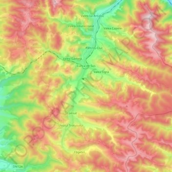
Name: Lunca de Sus topographic map, elevation, terrain.
Location: Lunca de Sus, Harghita, Romania (46.45689 25.88658 46.57120 26.08165)
Average elevation: 3,701 ft
Minimum elevation: 2,415 ft
Maximum elevation: 4,931 ft
Make a donation
Gear up for your next adventure:
As an Amazon Associate, this site earns from qualifying purchases at no extra cost to you.
Other topographic maps
Click on a map to view its topography, its elevation and its terrain.
Carpathian Mountains
The northwestern Carpathians begin in Slovakia and southern Poland. They surround Transcarpathia and Transylvania in a large semicircle, sweeping towards the southeast, and end on the Danube near Orșova in Romania. The total length of the Carpathians is over 1,500 km (930 mi) and the mountain chain's width…
Average elevation: 3,215 ft