Geolocate

Gheorgheni topographic map

Click on the map to display elevation.

About this map

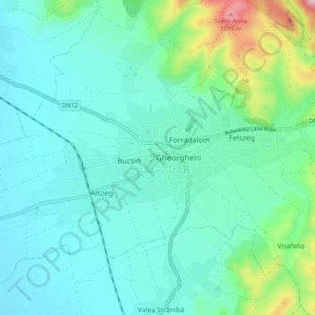
Name: Gheorgheni topographic map, elevation, terrain.

Location: Gheorgheni, Harghita, Romania (46.70775 25.55654 46.73490 25.64319)

Average elevation: 2,726 ft

Minimum elevation: 2,507 ft

Maximum elevation: 3,678 ft

Other topographic maps

Click on a map to view its topography, its elevation and its terrain.

Zetea

Romania > Harghita

Average elevation: 2,808 ft

Atia

Romania > Harghita

Average elevation: 2,346 ft

Lunca de Sus

Romania > Harghita

Average elevation: 3,701 ft

Carpathian Mountains

Romania > Harghita > Toplița

The northwestern Carpathians begin in Slovakia and southern Poland. They surround Transcarpathia and Transylvania in a large semicircle, sweeping towards the southeast, and end on the Danube near Orșova in Romania. The total length of the Carpathians is over 1,500 km (930 mi) and the mountain chain's width…

Average elevation: 3,215 ft

Toplița

Romania > Harghita

Average elevation: 3,488 ft

Gear up for your next adventure:

🔭Compact Binoculars - HD vision for scouting terrain and identifying distant landmarks
🕶️Glacier Sunglasses - Side shields to protect eyes from high-altitude snow glare
🚪Portable Camp Chair - Foldable chair for comfort at camp
🍳Camping Cook Set - Complete cookware for outdoor meals
🌡️Handheld Weather Meters - Measure wind, temp, and pressure for safe mountain travel

As an Amazon Associate, this site earns from qualifying purchases at no extra cost to you.