Geolocate

Grad Stari Grad topographic map

Click on the map to display elevation.

About this map

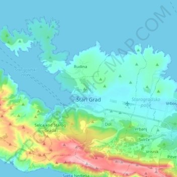
Name: Grad Stari Grad topographic map, elevation, terrain.

Location: Grad Stari Grad, Split-Dalmatia County, Croatia (43.14618 16.51915 43.23568 16.66927)

Average elevation: 335 ft

Minimum elevation: -3 ft

Maximum elevation: 2,014 ft

Other topographic maps

Click on a map to view its topography, its elevation and its terrain.

Baška Voda

Croatia > Split-Dalmatia County > Baška Voda

Average elevation: 709 ft

Umčani

Croatia > Split-Dalmatia County

Average elevation: 728 ft

Paklina

Croatia > Split-Dalmatia County > Tučepi > Paklina

Average elevation: 712 ft

Jelsa

Croatia > Split-Dalmatia County > Jelsa

Average elevation: 285 ft

Gear up for your next adventure:

🧼Biodegradable Camping Soap - Eco‑friendly soap for outdoor hygiene
📌Outdoor GPS Map App - Apps and devices for digital topographic navigation
🎁Geography Themed Gifts - Unique gift ideas for map lovers and geography enthusiasts
🪶Fire Starter Kit - Reliable fire starter for survival and camping
❄️Traction Cleats - Prevent slips on icy trails during winter hikes

As an Amazon Associate, this site earns from qualifying purchases at no extra cost to you.