
Make a donation
Gear up for your next adventure:
As an Amazon Associate, this site earns from qualifying purchases at no extra cost to you.
Westchester Valley topographic map
Click on the map to display elevation.
Make a donation
Gear up for your next adventure:
As an Amazon Associate, this site earns from qualifying purchases at no extra cost to you.
About this map
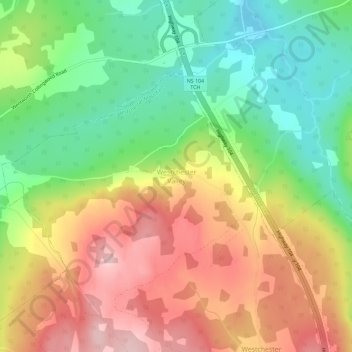
Name: Westchester Valley topographic map, elevation, terrain.
Average elevation: 636 ft
Minimum elevation: 302 ft
Maximum elevation: 1,014 ft
Make a donation
Gear up for your next adventure:
As an Amazon Associate, this site earns from qualifying purchases at no extra cost to you.
Other topographic maps
Click on a map to view its topography, its elevation and its terrain.
Advocate Harbour
Canada > Nova Scotia > Municipality of the County of Cumberland
Average elevation: 135 ft
Halfway River
Canada > Nova Scotia > Municipality of the County of Cumberland
Average elevation: 243 ft
Make a donation
Gear up for your next adventure:
As an Amazon Associate, this site earns from qualifying purchases at no extra cost to you.
East Mapleton
Canada > Nova Scotia > Municipality of the County of Cumberland
Average elevation: 610 ft
Make a donation
Gear up for your next adventure:
As an Amazon Associate, this site earns from qualifying purchases at no extra cost to you.
Maccan Woods
Canada > Nova Scotia > Municipality of the County of Cumberland
Average elevation: 135 ft
West Wentworth
Canada > Nova Scotia > Municipality of the County of Cumberland
Average elevation: 220 ft
Make a donation
Gear up for your next adventure:
As an Amazon Associate, this site earns from qualifying purchases at no extra cost to you.
Make a donation
Gear up for your next adventure:
As an Amazon Associate, this site earns from qualifying purchases at no extra cost to you.
North Wallace
Canada > Nova Scotia > Municipality of the County of Cumberland
Average elevation: 33 ft
West Leicester
Canada > Nova Scotia > Municipality of the County of Cumberland
Average elevation: 374 ft
East Southampton
Canada > Nova Scotia > Municipality of the County of Cumberland
Average elevation: 190 ft
Make a donation
Gear up for your next adventure:
As an Amazon Associate, this site earns from qualifying purchases at no extra cost to you.
Malagash Centre
Canada > Nova Scotia > Municipality of the County of Cumberland
Average elevation: 33 ft
Greenville Station
Canada > Nova Scotia > Municipality of the County of Cumberland
Average elevation: 305 ft
Make a donation
Gear up for your next adventure:
As an Amazon Associate, this site earns from qualifying purchases at no extra cost to you.
Make a donation
Gear up for your next adventure:
As an Amazon Associate, this site earns from qualifying purchases at no extra cost to you.
Upper Nappan
Canada > Nova Scotia > Municipality of the County of Cumberland
Average elevation: 118 ft
Make a donation
Gear up for your next adventure:
As an Amazon Associate, this site earns from qualifying purchases at no extra cost to you.
Malagash Point
Canada > Nova Scotia > Municipality of the County of Cumberland
Average elevation: 10 ft
Amherst Head
Canada > Nova Scotia > Municipality of the County of Cumberland
Average elevation: 131 ft
Amherst Shore
Canada > Nova Scotia > Municipality of the County of Cumberland
Average elevation: 52 ft
Make a donation
Gear up for your next adventure:
As an Amazon Associate, this site earns from qualifying purchases at no extra cost to you.
River Philip
Canada > Nova Scotia > Municipality of the County of Cumberland
Average elevation: 256 ft
Make a donation
Gear up for your next adventure:
As an Amazon Associate, this site earns from qualifying purchases at no extra cost to you.
Diligent River
Canada > Nova Scotia > Municipality of the County of Cumberland
Average elevation: 325 ft
Port Greville
Canada > Nova Scotia > Municipality of the County of Cumberland
Average elevation: 256 ft
Make a donation
Gear up for your next adventure:
As an Amazon Associate, this site earns from qualifying purchases at no extra cost to you.
Tidnish Cross Road
Canada > Nova Scotia > Municipality of the County of Cumberland
Average elevation: 56 ft
Make a donation
Gear up for your next adventure:
As an Amazon Associate, this site earns from qualifying purchases at no extra cost to you.
Make a donation
Gear up for your next adventure:
As an Amazon Associate, this site earns from qualifying purchases at no extra cost to you.
West Wentworth
Canada > Nova Scotia > Municipality of the County of Cumberland
Average elevation: 220 ft
Make a donation
Gear up for your next adventure:
As an Amazon Associate, this site earns from qualifying purchases at no extra cost to you.
Oxford Junction
Canada > Nova Scotia > Municipality of the County of Cumberland
Average elevation: 138 ft
Make a donation
Gear up for your next adventure:
As an Amazon Associate, this site earns from qualifying purchases at no extra cost to you.