
Make a donation
Gear up for your next adventure:
As an Amazon Associate, this site earns from qualifying purchases at no extra cost to you.
Port Philip topographic map
Click on the map to display elevation.
Make a donation
Gear up for your next adventure:
As an Amazon Associate, this site earns from qualifying purchases at no extra cost to you.
About this map
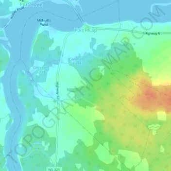
Name: Port Philip topographic map, elevation, terrain.
Average elevation: 39 ft
Minimum elevation: -3 ft
Maximum elevation: 148 ft
Make a donation
Gear up for your next adventure:
As an Amazon Associate, this site earns from qualifying purchases at no extra cost to you.
Other topographic maps
Click on a map to view its topography, its elevation and its terrain.
Chignecto Isthmus
Canada > Nova Scotia > Municipality of the County of Cumberland > Fort Lawrence
Average elevation: 46 ft
River Philip Centre
Canada > Nova Scotia > Municipality of the County of Cumberland
Average elevation: 279 ft
Mullins Point
Canada > Nova Scotia > Municipality of the County of Cumberland > North Wallace
Average elevation: 7 ft
Blue Sea Corner
Canada > Nova Scotia > Municipality of the County of Cumberland > Malagash Point
Average elevation: 36 ft
Make a donation
Gear up for your next adventure:
As an Amazon Associate, this site earns from qualifying purchases at no extra cost to you.
Westchester Valley
Canada > Nova Scotia > Municipality of the County of Cumberland
Average elevation: 636 ft
Glasgow Mountain
Canada > Nova Scotia > Municipality of the County of Cumberland > Diligent River
Average elevation: 469 ft
Two Rivers
Canada > Nova Scotia > Municipality of the County of Cumberland > Joggins
Average elevation: 171 ft
Canaan Mountains
Canada > Nova Scotia > Municipality of the County of Cumberland > New Canaan
Average elevation: 318 ft
Make a donation
Gear up for your next adventure:
As an Amazon Associate, this site earns from qualifying purchases at no extra cost to you.
Cameron Beach
Canada > Nova Scotia > Municipality of the County of Cumberland > Port Howe
Average elevation: 7 ft
Pugwash Point
Canada > Nova Scotia > Municipality of the County of Cumberland > Pugwash
Average elevation: 13 ft
Upper Gulf Shore
Canada > Nova Scotia > Municipality of the County of Cumberland > Gulf Shore
Average elevation: 39 ft
Mitchells Beach
Canada > Nova Scotia > Municipality of the County of Cumberland > West Pugwash
Average elevation: 23 ft
Make a donation
Gear up for your next adventure:
As an Amazon Associate, this site earns from qualifying purchases at no extra cost to you.
Cape Chignecto
Canada > Nova Scotia > Municipality of the County of Cumberland > Cape Chignecto Provincial Park
Average elevation: 66 ft
Cape Chignecto
Canada > Nova Scotia > Municipality of the County of Cumberland > Cape Chignecto Provincial Park
Average elevation: 66 ft