
Beaver Meadows topographic map
Click on the map to display elevation.
Beaver Meadows
Beaver Meadow is at an elevation of 1,598 feet (487 m) above sea level in the valley of Beaver Creek, north of Spring Mountain, part of the Ridge-and-Valley Appalachians. According to the United States Census Bureau, the borough has a total area of 0.26 square miles (0.67 km2), all of it land.
About this map
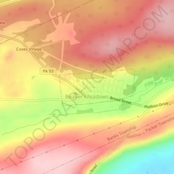
Name: Beaver Meadows topographic map, elevation, terrain.
Average elevation: 1,683 ft
Minimum elevation: 1,283 ft
Maximum elevation: 1,893 ft
Carbon County trails, hiking, mountain biking, running and outdoor activities
Other topographic maps
Click on a map to view its topography, its elevation and its terrain.
Beltzville Lake
United States > Pennsylvania > Carbon County > Towamensing Township
Average elevation: 886 ft
Leonardsville
United States > Pennsylvania > Carbon County > Kidder Township
Average elevation: 1,660 ft
White Bear Creek
United States > Pennsylvania > Carbon County > Summit Hill
Average elevation: 1,332 ft
Pisgah Mountain
United States > Pennsylvania > Carbon County > Summit Hill
Average elevation: 1,322 ft
Lake Harmony
United States > Pennsylvania > Carbon County > Kidder Township
Average elevation: 1,808 ft
Pleasant Corners
United States > Pennsylvania > Carbon County > Mahoning Township
Average elevation: 732 ft
Christian Corner
United States > Pennsylvania > Carbon County > Lower Towamensing Township
Average elevation: 741 ft
East Jim Thorpe
United States > Pennsylvania > Carbon County > Jim Thorpe > East Jim Thorpe
Average elevation: 892 ft