
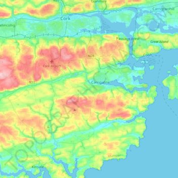
Municipal District of Carrigaline topographic map
Interactive map
Click on the map to display elevation.
About this map
Name: Municipal District of Carrigaline topographic map, elevation, terrain.
Average elevation: 171 ft
Minimum elevation: -10 ft
Maximum elevation: 646 ft
Other topographic maps
Click on a map to view its topography, its elevation and its terrain.
Kilmichael
Kilmichael, Carrigboy ED, Municipal District of Macroom, County Cork, Munster, P12 W864, Ireland
Average elevation: 436 ft
Macroom
Macroom, Municipal District of Macroom, County Cork, Munster, Ireland
Average elevation: 361 ft
Leamlara
Leamlara, Lisgoold, The Municipal District of East Cork, County Cork, Munster, T56 NH57, Ireland
Average elevation: 476 ft
Matehy
Matehy, Municipal District of Macroom, County Cork, Munster, Ireland
Average elevation: 351 ft
Newmarket
Newmarket, The Municipal District of Kanturk-Mallow, County Cork, Munster, Ireland
Average elevation: 554 ft
Watergrasshill
Watergrasshill, Municipal District of Cobh, County Cork, Munster, Ireland
Average elevation: 538 ft
Cork City
Ireland > County Cork > Cork
Cork City, Cork, County Cork, Munster, Ireland
Average elevation: 217 ft
Halfway
Halfway, Dunderrow, Municipal District of Carrigaline, County Cork, Munster, T12 KT99, Ireland
Average elevation: 315 ft
Killumney
Killumney, Ballygroman ED, Municipal District of Macroom, County Cork, Munster, Ireland
Average elevation: 259 ft
Bandon
Bandon, The Municipal District of Bandon-Kinsale, County Cork, Munster, Ireland
Average elevation: 194 ft
Minane Bridge
Minane Bridge, Municipal District of Carrigaline, County Cork, Munster, P17 K725, Ireland
Average elevation: 230 ft
Coole East
Coole East, Rathcooney, Municipal District of Cobh, County Cork, Munster, Ireland
Average elevation: 371 ft
Model Village
Model Village, Dripsey, Municipal District of Macroom, County Cork, Munster, Ireland
Average elevation: 328 ft
Lisgoold
Lisgoold, The Municipal District of East Cork, County Cork, Munster, T56 NH57, Ireland
Average elevation: 367 ft
Ballymore
Ballymore, Cobh Rural ED, Municipal District of Cobh, County Cork, Munster, Ireland
Average elevation: 131 ft
Kilcully
Ireland > County Cork > Cork
Kilcully, Rathcooney, Cork, County Cork, Munster, T23 HP30, Ireland
Average elevation: 272 ft
Ballincurrig
Ballincurrig, Inch, The Municipal District of East Cork, County Cork, Munster, Ireland
Average elevation: 135 ft
Ballygarvan
Ballygarvan, Municipal District of Carrigaline, County Cork, Munster, T12 RR02, Ireland
Average elevation: 230 ft
Cloyne
Cloyne, Cloyne ED, The Municipal District of East Cork, County Cork, Munster, P25 P792, Ireland
Average elevation: 131 ft
Midleton
Midleton, The Municipal District of East Cork, County Cork, Munster, Ireland
Average elevation: 59 ft
Queenstown No 2 Registrars District
Ireland > County Cork > Municipal District of Cobh
Queenstown No 2 Registrars District, Municipal District of Cobh, County Cork, Munster, Ireland
Average elevation: 85 ft
Glenbrook
Ireland > County Cork > Municipal District of Carrigaline
Glenbrook, Municipal District of Carrigaline, County Cork, Munster, T12 KT5N, Ireland
Average elevation: 164 ft
The Municipal District of Kanturk – Mallow
The Municipal District of Kanturk – Mallow, County Cork, Munster, Ireland
Average elevation: 597 ft
Lee Fields
Ireland > County Cork > Cork
Lee Fields, Bishopstown ED A, Cork, County Cork, Munster, Ireland
Average elevation: 161 ft
Macroom
Ireland > County Cork > Blarney - Macroom > Macroom
Macroom, Blarney - Macroom, County Cork, Munster, P12 WK38, Ireland
Average elevation: 377 ft
Douglas
Ireland > County Cork > Cork
Douglas, Cork, County Cork, Munster, Ireland
Average elevation: 112 ft
Knocknagree
Knocknagree, The Municipal District of Kanturk – Mallow, County Cork, Munster, P51 PD71, Ireland
Average elevation: 600 ft
The Municipal District of Bandon – Kinsale
The Municipal District of Bandon – Kinsale, County Cork, Munster, Ireland
Average elevation: 226 ft
Monkstown
Ireland > County Cork > Municipal District of Carrigaline
Monkstown, Municipal District of Carrigaline, County Cork, Munster, T12 KT5N, Ireland
Average elevation: 144 ft
Mount Gabriel
Mount Gabriel, West Cork, County Cork, Munster, P81 K256, Ireland
Average elevation: 564 ft
Macroom
Ireland > County Cork > Municipal District of Macroom
Macroom, Municipal District of Macroom, County Cork, Munster, Ireland
Average elevation: 689 ft
Gortnacarriga
Gortnacarriga, Crookhaven ED, West Cork, County Cork, Munster, Ireland
Average elevation: 197 ft
Desert
Desert, Clonakilty Urban ED, West Cork, County Cork, Munster, P85 YX60, Ireland
Average elevation: 128 ft
Castletownbere
Ireland > County Cork > Castletownbere
Castletownbere, West Cork, County Cork, Munster, P75 DK33, Ireland
Average elevation: 289 ft
Cobh
Ireland > County Cork > Cobh Municipal District > Cobh
Cobh, Cobh Municipal District, County Cork, Munster, P43 XV65, Ireland
Average elevation: 75 ft
Mitchelstown
Ireland > County Cork > Mitchelstown
Mitchelstown, The Municipal District of Fermoy, County Cork, Munster, P67 FR62, Ireland
Average elevation: 417 ft
Nad
Nad, Tincoora, The Municipal District of Kanturk – Mallow, County Cork, Munster, Ireland
Average elevation: 774 ft
The Municipal District of East Cork
The Municipal District of East Cork, County Cork, Munster, Ireland
Average elevation: 194 ft
Blarney
Ireland > County Cork > Blarney - Macroom > Blarney
Blarney, Blarney - Macroom, County Cork, Munster, T23 YA34, Ireland
Average elevation: 272 ft
Lackenroe
Ireland > County Cork > Cobh Municipal District
Lackenroe, Caherlag ED, Cobh Municipal District, County Cork, Munster, Ireland
Average elevation: 289 ft
Blarney - Macroom
Ireland > County Cork > Blarney - Macroom
Blarney - Macroom, County Cork, Munster, Ireland
Average elevation: 528 ft
Kinsale
Ireland > County Cork > Kinsale
Kinsale, The Municipal District of Bandon – Kinsale, County Cork, Munster, P17 H590, Ireland
Average elevation: 144 ft
Ballingeary
Ireland > County Cork > Municipal District of Macroom
Ballingeary, Municipal District of Macroom, County Cork, Munster, P12 PC04, Ireland
Average elevation: 515 ft