Geolocate

Harding topographic map

Click on the map to display elevation.

About this map

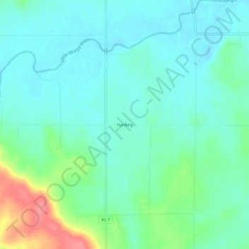
Name: Harding topographic map, elevation, terrain.

Location: Harding, Bourbon County, Kansas, 66764, United States (37.97392 -94.83969 38.01392 -94.79969)

Average elevation: 876 ft

Minimum elevation: 814 ft

Maximum elevation: 1,066 ft

Bourbon County trails, hiking, mountain biking, running and outdoor activities

Other topographic maps

Click on a map to view its topography, its elevation and its terrain.

Mapleton

United States > Kansas > Bourbon County

Average elevation: 876 ft

Redfield

United States > Kansas > Bourbon County

Average elevation: 863 ft

Fulton

United States > Kansas > Bourbon County

Average elevation: 827 ft

Bronson

United States > Kansas > Bourbon County

Average elevation: 1,060 ft

Gear up for your next adventure:

🪵Folding Camp Saw - Compact saw for wood and campsite work
📦Gear Storage Bags - Organize and protect outdoor equipment
🧯Portable Fire Pit - Compact fire pit for camping spots
🧭GPS Watch Accessories - Bands and chargers for GPS watches
🎒Trail Energy Bars - High‑calorie bars for hiking energy

As an Amazon Associate, this site earns from qualifying purchases at no extra cost to you.