Geolocate

Redfield topographic map

Click on the map to display elevation.

About this map

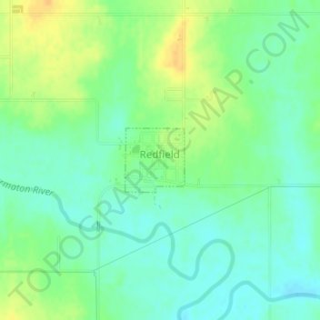
Name: Redfield topographic map, elevation, terrain.

Location: Redfield, Bourbon County, Kansas, United States (37.83366 -94.88455 37.83908 -94.87818)

Average elevation: 863 ft

Minimum elevation: 823 ft

Maximum elevation: 915 ft

Bourbon County trails, hiking, mountain biking, running and outdoor activities

Other topographic maps

Click on a map to view its topography, its elevation and its terrain.

Xenia

United States > Kansas > Bourbon County

Average elevation: 968 ft

Porterville

United States > Kansas > Bourbon County

Average elevation: 1,040 ft

Pawnee Station

United States > Kansas > Bourbon County

Average elevation: 971 ft

Marmaton

United States > Kansas > Bourbon County

Average elevation: 873 ft

Hiattville

United States > Kansas > Bourbon County

Average elevation: 961 ft

Harding

United States > Kansas > Bourbon County

Average elevation: 876 ft

Hammond

United States > Kansas > Bourbon County

Average elevation: 873 ft

Godfrey

United States > Kansas > Bourbon County

Average elevation: 942 ft

Garland

United States > Kansas > Bourbon County

Average elevation: 850 ft

Devon

United States > Kansas > Bourbon County

Average elevation: 879 ft

Barnesville

United States > Kansas > Bourbon County

Average elevation: 827 ft

Gear up for your next adventure:

🧭GPS Watch Accessories - Bands and chargers for GPS watches
🗺️NatGeo Topo Maps - High-quality waterproof printed topographic maps of US Parks
🖼️Topo Map Wall Art - Decorative topographic prints of famous peaks and regions
🪄Magnetic Compass - Accurate compass for navigation
📦Gear Storage Bags - Organize and protect outdoor equipment

As an Amazon Associate, this site earns from qualifying purchases at no extra cost to you.