Geolocate

Fulton topographic map

Click on the map to display elevation.

About this map

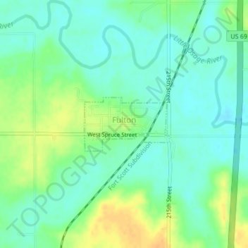
Name: Fulton topographic map, elevation, terrain.

Location: Fulton, Bourbon County, Kansas, 66738, United States (38.00663 -94.72518 38.01248 -94.71345)

Average elevation: 827 ft

Minimum elevation: 791 ft

Maximum elevation: 889 ft

Bourbon County trails, hiking, mountain biking, running and outdoor activities

Other topographic maps

Click on a map to view its topography, its elevation and its terrain.

Hammond

United States > Kansas > Bourbon County

Average elevation: 873 ft

Xenia

United States > Kansas > Bourbon County

Average elevation: 968 ft

Porterville

United States > Kansas > Bourbon County

Average elevation: 1,040 ft

Pawnee Station

United States > Kansas > Bourbon County

Average elevation: 971 ft

Marmaton

United States > Kansas > Bourbon County

Average elevation: 873 ft

Hiattville

United States > Kansas > Bourbon County

Average elevation: 961 ft

Harding

United States > Kansas > Bourbon County

Average elevation: 876 ft

Godfrey

United States > Kansas > Bourbon County

Average elevation: 942 ft

Garland

United States > Kansas > Bourbon County

Average elevation: 850 ft

Devon

United States > Kansas > Bourbon County

Average elevation: 879 ft

Barnesville

United States > Kansas > Bourbon County

Average elevation: 827 ft

Gear up for your next adventure:

Camping Coffee Makers - Enjoy premium coffee at the summit or campsite
🪑Ultralight Camp Chairs - Portable seating for resting after a long day of mapping
🌎3D Topographic Globes - Raised relief globes for a tactile understanding of geography
🛠️Outdoor Gear Repair Kit - Essential tools to fix gear on the trail
🧭Hiking Compass - Precision compass for reliable navigation in the wilderness

As an Amazon Associate, this site earns from qualifying purchases at no extra cost to you.