Geolocate

Branch topographic map

Click on the map to display elevation.

About this map

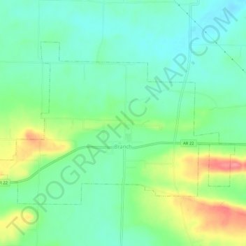
Name: Branch topographic map, elevation, terrain.

Location: Branch, Franklin County, Arkansas, 72928, United States (35.29575 -93.98162 35.32354 -93.93015)

Average elevation: 486 ft

Minimum elevation: 397 ft

Maximum elevation: 669 ft

Franklin County trails, hiking, mountain biking, running and outdoor activities

Other topographic maps

Click on a map to view its topography, its elevation and its terrain.

Alix

United States > Arkansas > Franklin County

Average elevation: 423 ft

Cecil

United States > Arkansas > Franklin County

Average elevation: 764 ft

Peanut

United States > Arkansas > Franklin County

Average elevation: 1,220 ft

Vesta

United States > Arkansas > Franklin County

Average elevation: 482 ft

Webb City

United States > Arkansas > Franklin County

Average elevation: 443 ft

Mountain Top

United States > Arkansas > Franklin County

Average elevation: 1,575 ft

Redding

United States > Arkansas > Franklin County > Redding

Average elevation: 1,010 ft

Gear up for your next adventure:

🪶Survival Guide Book - Expert advice for emergency preparedness
🔥Fast-Boil Camping Stoves - Efficient cooking systems for quick trail meals
📡Handheld GPS Device - Reliable handheld GPS for outdoor navigation
📱Heavy-Duty Phone Cases - Drop-proof and waterproof protection for outdoor navigation
Camping Coffee Makers - Enjoy premium coffee at the summit or campsite

As an Amazon Associate, this site earns from qualifying purchases at no extra cost to you.