Geolocate

Bypro topographic map

Click on the map to display elevation.

About this map

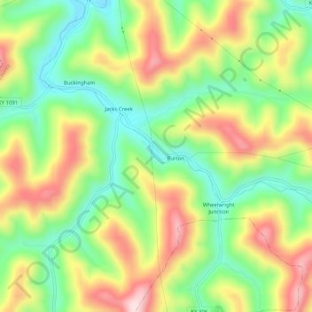
Name: Bypro topographic map, elevation, terrain.

Location: Bypro, Floyd County, Kentucky, 41612, United States (37.33984 -82.74688 37.37984 -82.70688)

Average elevation: 1,309 ft

Minimum elevation: 830 ft

Maximum elevation: 1,919 ft

Floyd County trails, hiking, mountain biking, running and outdoor activities

Other topographic maps

Click on a map to view its topography, its elevation and its terrain.

Wheelwright

United States > Kentucky > Floyd County

Average elevation: 1,460 ft

Allen

United States > Kentucky > Floyd County

Average elevation: 856 ft

Martin

United States > Kentucky > Floyd County

Average elevation: 883 ft

Gear up for your next adventure:

👓Polarized Sunglasses - Outdoor sunglasses for glare reduction
📷Action Camera - Capture your outdoor adventures in HD
🩹Survival Bandages - High‑quality bandages for emergencies
🧭Compass with Lanyard - Easy‑carry compass for navigation
🪵Folding Camp Saw - Compact saw for wood and campsite work

As an Amazon Associate, this site earns from qualifying purchases at no extra cost to you.