Geolocate

Allen topographic map

Click on the map to display elevation.

About this map

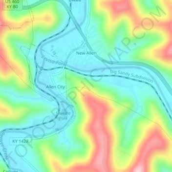
Name: Allen topographic map, elevation, terrain.

Location: Allen, Floyd County, Kentucky, United States (37.60198 -82.73468 37.61728 -82.72101)

Average elevation: 856 ft

Minimum elevation: 610 ft

Maximum elevation: 1,332 ft

Floyd County trails, hiking, mountain biking, running and outdoor activities

Other topographic maps

Click on a map to view its topography, its elevation and its terrain.

Bosco

United States > Kentucky > Floyd County

Average elevation: 932 ft

Melvin

United States > Kentucky > Floyd County

Average elevation: 1,411 ft

Drift

United States > Kentucky > Floyd County

Average elevation: 1,024 ft

Beaver

United States > Kentucky > Floyd County

Average elevation: 1,453 ft

Teaberry

United States > Kentucky > Floyd County

Average elevation: 1,296 ft

Printer

United States > Kentucky > Floyd County

Average elevation: 971 ft

Stanville

United States > Kentucky > Floyd County

Average elevation: 922 ft

Hueysville

United States > Kentucky > Floyd County

Average elevation: 945 ft

Ivel

United States > Kentucky > Floyd County

Average elevation: 925 ft

Hi Hat

United States > Kentucky > Floyd County

Average elevation: 1,257 ft

Garrett

United States > Kentucky > Floyd County

Average elevation: 958 ft

David

United States > Kentucky > Floyd County

Average elevation: 1,070 ft

Dana

United States > Kentucky > Floyd County

Average elevation: 1,056 ft

Bypro

United States > Kentucky > Floyd County

Average elevation: 1,309 ft

Banner

United States > Kentucky > Floyd County

Average elevation: 912 ft

Dwale

United States > Kentucky > Floyd County

Average elevation: 886 ft

Betsy Layne

United States > Kentucky > Floyd County

Average elevation: 886 ft

McDowell

United States > Kentucky > Floyd County

Average elevation: 1,063 ft

Ligon

United States > Kentucky > Floyd County

Average elevation: 1,480 ft

Blue River

United States > Kentucky > Floyd County

Average elevation: 909 ft

Weeksbury

United States > Kentucky > Floyd County

Average elevation: 1,598 ft

Minnie

United States > Kentucky > Floyd County

Average elevation: 1,037 ft

Dema

United States > Kentucky > Floyd County

Average elevation: 1,165 ft

Welco Station

United States > Kentucky > Floyd County

Average elevation: 948 ft

Gear up for your next adventure:

🧯Portable Fire Pit - Compact fire pit for camping spots
🦶Carbon Trekking Poles - Reduce knee impact on steep descents with ultra-light poles
🥾Hiking Shoes - Durable and comfortable shoes for trail hiking
🩹Survival Bandages - High‑quality bandages for emergencies
🔋Rechargeable Batteries - Power up your outdoor devices

As an Amazon Associate, this site earns from qualifying purchases at no extra cost to you.