
Make a donation
Gear up for your next adventure:
As an Amazon Associate, this site earns from qualifying purchases at no extra cost to you.
Brokstedt topographic map
Click on the map to display elevation.
Make a donation
Gear up for your next adventure:
As an Amazon Associate, this site earns from qualifying purchases at no extra cost to you.
Brokstedt
Die Gemeinde Brokstedt besteht siedlungsgeografisch aus einer Mehrzahl von Ortsteilen, die amtlich als Wohnplätze verzeichnet sind. Neben dem für die Gemeinde namenstiftenden Kirchdorf zählen ebenfalls die Häusergruppen Osterfeld, Rotensande und Sibbersdorf sowie die Hofsiedlungen Brokstedtfeld, Butterkamp, Krim, Ludwigshöhe und Mittelhof als weitere Siedlungsplätze zur Gemeinde.
Make a donation
Gear up for your next adventure:
As an Amazon Associate, this site earns from qualifying purchases at no extra cost to you.
About this map
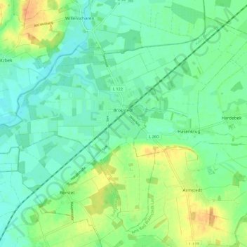
Name: Brokstedt topographic map, elevation, terrain.
Average elevation: 49 ft
Minimum elevation: 10 ft
Maximum elevation: 128 ft
Make a donation
Gear up for your next adventure:
As an Amazon Associate, this site earns from qualifying purchases at no extra cost to you.
Other topographic maps
Click on a map to view its topography, its elevation and its terrain.
Rhinplate und Elbufer südlich Glückstadt
Deutschland > Schleswig-Holstein > Kreis Steinburg > Kollmar
Average elevation: 0 ft
Make a donation
Gear up for your next adventure:
As an Amazon Associate, this site earns from qualifying purchases at no extra cost to you.
Make a donation
Gear up for your next adventure:
As an Amazon Associate, this site earns from qualifying purchases at no extra cost to you.
Springhoe
Deutschland > Schleswig-Holstein > Kreis Steinburg > Hohenlockstedt
Average elevation: 66 ft
Kaaksburg
Deutschland > Schleswig-Holstein > Kreis Steinburg > Kaaks
Über ihre Entstehung und Funktion ist nicht viel bekannt. Der ovale Ringwall mit einem Durchmesser von 80 bzw. 100 m und einer Höhe von ca. 5 m wurde aus dunkler Erde aufgeworfen, während der Boden in der Umgebung sandig ist, weshalb angenommen wurde, dass das Material aus der im Südosten vorbeifließenden…
Average elevation: 36 ft
Make a donation
Gear up for your next adventure:
As an Amazon Associate, this site earns from qualifying purchases at no extra cost to you.
Springhoe
Deutschland > Schleswig-Holstein > Kreis Steinburg > Hohenlockstedt
Average elevation: 66 ft