Geolocate

Samal topographic map

Click on the map to display elevation.

About this map

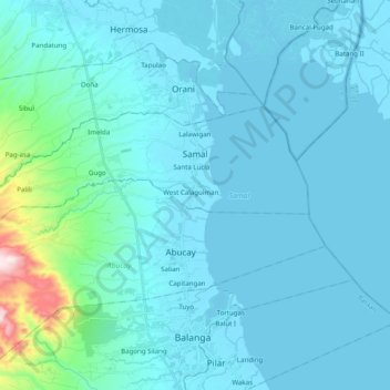
Name: Samal topographic map, elevation, terrain.

Location: Samal, Bataan, Central Luzon, 2113, Philippines (14.70537 120.40274 14.79270 120.59988)

Average elevation: 180 ft

Minimum elevation: -7 ft

Maximum elevation: 2,096 ft

Other topographic maps

Click on a map to view its topography, its elevation and its terrain.

Mariveles

Philippines > Bataan > Mariveles

Mariveles features a diverse and dynamic topography characterized by its mountainous terrain and coastal landscapes. The region is dominated by the prominent Mount Mariveles, a stratovolcano that reaches an elevation of approximately 4,531 feet (1,388 meters) at its highest point. The mountain is part of a…

Average elevation: 272 ft

Balanga

Philippines > Bataan > Balanga

Average elevation: 440 ft

Abucay

Philippines > Bataan > Abucay

Topography of Abucay varies from the mountainous terrain of Mount Natib caldera in the west to the coastal areas of the province along the shore of Manila Bay. Six rivers with a combined length of 37 kilometres (23 mi) originate from the mountain flowing in the west-to-east direction.

Average elevation: 72 ft

Hamlet

Philippines > Bataan > Bagac

Average elevation: 184 ft

Palihan

Philippines > Bataan > Hermosa

Average elevation: 49 ft

Maligaya

Philippines > Bataan > Mariveles

Average elevation: 440 ft

Lucanin

Philippines > Bataan > Mariveles

Average elevation: 75 ft

Kaparangan

Philippines > Bataan > Orani

Average elevation: 20 ft

Lupang Hinirang

Philippines > Bataan > Orani > Tugatog

Average elevation: 33 ft

Pag-asa

Philippines > Bataan > Bagac

Average elevation: 62 ft

Camachile

Philippines > Bataan > Orion

Average elevation: 10 ft

Tuyo

Philippines > Bataan > Balanga

Average elevation: 33 ft

Mount Mariveles

Philippines > Bataan > Mariveles

Mount Mariveles is a massive stratovolcano topped with a 4-kilometre (2.5 mi) summit caldera which drains to the north. The highest peak, called Mariveles, has an elevation of 1,388 metres (4,554 ft) asl. Mounts Pantingan, Bataan, Tarak, and Vintana are the other peaks of the volcano-caldera complex, which has…

Average elevation: 2,884 ft

Bagac

Philippines > Bataan

Average elevation: 200 ft

Cabcaben

Philippines > Bataan > Mariveles

Average elevation: 69 ft

Sibul

Philippines > Bataan > Orani

Average elevation: 466 ft

Binuangan

Philippines > Bataan > Bagac

Average elevation: 131 ft

Quinawan

Philippines > Bataan > Quinawan

Average elevation: 157 ft

Mabayo

Philippines > Bataan > Morong

Average elevation: 194 ft

Orion

Philippines > Bataan > Orion

Average elevation: 69 ft

Bamban

Philippines > Bataan > Bamban

Average elevation: 108 ft

Manila Bay

Philippines > Bataan

Average elevation: 0 ft

Baseco Country

Philippines > Bataan

Average elevation: 253 ft

Gear up for your next adventure:

🦟Ultrasonic Repellers - Create a bug-free zone at your camp or rest stop
🚑Emergency Bivvies - Heat-reflective sleeping bags for survival situations
🧥Men's Rain Shells - Premium waterproof and breathable jackets for mountain weather
🛠️Outdoor Gear Repair Kit - Essential tools to fix gear on the trail
🧢Sun Protection Hats - Wide-brimmed and UPF-rated hats for high-altitude sun safety

As an Amazon Associate, this site earns from qualifying purchases at no extra cost to you.