
Bukhan River topographic map
Interactive map
Click on the map to display elevation.
About this map
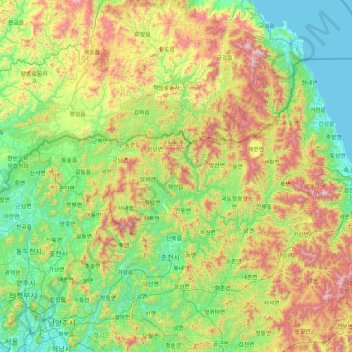
Name: Bukhan River topographic map, elevation, terrain.
Location: Bukhan River, North Korea (37.52487 127.30736 38.83181 127.90345)
Average elevation: 1,385 ft
Minimum elevation: 0 ft
Maximum elevation: 5,322 ft
Other topographic maps
Click on a map to view its topography, its elevation and its terrain.
긴마을동
긴마을동, Moranbong District, P'yŏngyang, North Korea
Average elevation: 89 ft
U-do
U-do, Chongdan County, South Hwanghae, North Korea
Average elevation: 49 ft
Kaesong
North Korea > Kaesong > Phanmun-guyok
Kaesong, Phanmun-guyok, Kaesong, North Korea
Average elevation: 279 ft
Pyŏngsŏng
North Korea > Pyongannam-do > Pyŏngsŏng
Pyŏngsŏng, Pyongannam-do, North Korea
Average elevation: 374 ft
Samjiyon
North Korea > Ryanggang > Samjiyon
Samjiyon, Samjiyon County, Ryanggang, North Korea
Average elevation: 4,636 ft
Kumchon County
Kumchon County, Hwanghaebuk-do, North Korea
Average elevation: 436 ft
Paektu Mountain
Paektu Mountain, Samjiyon County, Ryanggang, North Korea
Average elevation: 7,241 ft
Imnam Dam
Imnam Dam, Kimhwa County, Kangwon-do, North Korea
Average elevation: 968 ft