
Make a donation
Gear up for your next adventure:
As an Amazon Associate, this site earns from qualifying purchases at no extra cost to you.
Hantam Local Municipality topographic map
Click on the map to display elevation.
Make a donation
Gear up for your next adventure:
As an Amazon Associate, this site earns from qualifying purchases at no extra cost to you.
About this map
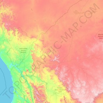
Name: Hantam Local Municipality topographic map, elevation, terrain.
Average elevation: 2,631 ft
Minimum elevation: 0 ft
Maximum elevation: 6,404 ft
Make a donation
Gear up for your next adventure:
As an Amazon Associate, this site earns from qualifying purchases at no extra cost to you.
Other topographic maps
Click on a map to view its topography, its elevation and its terrain.
Witbank
South Africa > Northern Cape > Namakwa District Municipality > Khâi-Ma Local Municipality
Average elevation: 935 ft
Soutpansberg
South Africa > Northern Cape > Namakwa District Municipality > Hantam Local Municipality
Average elevation: 3,839 ft
Springbok
South Africa > Northern Cape > Namakwa District Municipality > Nama Khoi Local Municipality
The town lies at an elevation of 1,007 metres (3,304 feet) in a narrow valley between the high granite domes of the Klein Koperberge (Small Copper Mountains). This name gives away the reason for the early settlement which gradually turned into a major commercial and administrative centre for copper mining…
Average elevation: 3,041 ft
Sutherland
South Africa > Northern Cape > Namakwa District Municipality > Karoo Hoogland Local Municipality
Average elevation: 5,030 ft
Make a donation
Gear up for your next adventure:
As an Amazon Associate, this site earns from qualifying purchases at no extra cost to you.
Brandvlei
South Africa > Northern Cape > Namakwa District Municipality > Hantam Local Municipality
Average elevation: 3,028 ft
Tafelkop
South Africa > Northern Cape > Namakwa District Municipality > Karoo Hoogland Local Municipality
Average elevation: 4,780 ft
Bluff
South Africa > Northern Cape > Namakwa District Municipality > Nama Khoi Local Municipality
Average elevation: 2,513 ft
Jonkershoek
South Africa > Northern Cape > Namakwa District Municipality > Hantam Local Municipality
Average elevation: 4,262 ft
Make a donation
Gear up for your next adventure:
As an Amazon Associate, this site earns from qualifying purchases at no extra cost to you.
Tankwa Karoo National Park - Gate - No Entry
South Africa > Northern Cape > Namakwa District Municipality > Karoo Hoogland Local Municipality
Average elevation: 1,611 ft
Kamieskroon
South Africa > Northern Cape > Namakwa District Municipality > Kamiesberg Local Municipality
Kamieskroon is a small town in the Kamiesberg Local Municipality, lying in the foothills of the Kamiesberge at an elevation of approximately 800 m (2 600 ft). The town is more or less in the centre of Namaqualand, about 70 km (43 mi) to the south of Springbok, Northern Cape, South Africa. It is known mainly…
Average elevation: 2,589 ft
Nababeep
South Africa > Northern Cape > Namakwa District Municipality > Nama Khoi Local Municipality
Average elevation: 3,009 ft
Renoster
South Africa > Northern Cape > Namakwa District Municipality > Karoo Hoogland Local Municipality
Average elevation: 4,590 ft
Make a donation
Gear up for your next adventure:
As an Amazon Associate, this site earns from qualifying purchases at no extra cost to you.
Port Nolloth
South Africa > Northern Cape > Namakwa District Municipality > Richtersveld Local Municipality
Average elevation: 39 ft
Pofadder
South Africa > Northern Cape > Namakwa District Municipality > Khâi-Ma Local Municipality
Average elevation: 3,271 ft
Calvinia
South Africa > Northern Cape > Namakwa District Municipality > Hantam Local Municipality
The town is 301 kilometers (470 kilometers by tar road) north of Cape Town and lies at an altitude of 970 meters.
Average elevation: 3,356 ft
Buffels
South Africa > Northern Cape > Namakwa District Municipality > Nama Khoi Local Municipality > Kleinsee
Average elevation: 59 ft
Make a donation
Gear up for your next adventure:
As an Amazon Associate, this site earns from qualifying purchases at no extra cost to you.
Loeriesfontein
South Africa > Northern Cape > Namakwa District Municipality > Hantam Local Municipality
Average elevation: 2,963 ft
Fraserburg
South Africa > Northern Cape > Namakwa District Municipality > Karoo Hoogland Local Municipality
Fraserburg is situated at an altitude of 1,385 metres (4,544 ft) above sea level on a high Karoo plateau, north of the Nuweveld Mountains.
Average elevation: 4,160 ft
Loeriesfontein
South Africa > Northern Cape > Namakwa District Municipality > Hantam Local Municipality
Average elevation: 2,963 ft
Aggeneys
South Africa > Northern Cape > Namakwa District Municipality > Khâi-Ma Local Municipality
Average elevation: 2,900 ft
Make a donation
Gear up for your next adventure:
As an Amazon Associate, this site earns from qualifying purchases at no extra cost to you.
Calvinia
South Africa > Northern Cape > Namakwa District Municipality > Hantam Local Municipality
The town is 301 kilometers (470 kilometers by tar road) north of Cape Town and lies at an altitude of 970 meters.
Average elevation: 3,356 ft
Springbok
South Africa > Northern Cape > Namakwa District Municipality > Nama Khoi Local Municipality
The town lies at an elevation of 1,007 metres (3,304 feet) in a narrow valley between the high granite domes of the Klein Koperberge (Small Copper Mountains). This name gives away the reason for the early settlement which gradually turned into a major commercial and administrative centre for copper mining…
Average elevation: 3,041 ft
Witbank
South Africa > Northern Cape > Namakwa District Municipality > Khâi-Ma Local Municipality
Average elevation: 935 ft
Springbok
South Africa > Northern Cape > Namakwa District Municipality > Nama Khoi Local Municipality
The town lies at an elevation of 1,007 metres (3,304 feet) in a narrow valley between the high granite domes of the Klein Koperberge (Small Copper Mountains). This name gives away the reason for the early settlement which gradually turned into a major commercial and administrative centre for copper mining…
Average elevation: 3,041 ft
Make a donation
Gear up for your next adventure:
As an Amazon Associate, this site earns from qualifying purchases at no extra cost to you.
Pofadder
South Africa > Northern Cape > Namakwa District Municipality > Khâi-Ma Local Municipality
Average elevation: 3,271 ft
Brandvlei
South Africa > Northern Cape > Namakwa District Municipality > Hantam Local Municipality
Average elevation: 3,028 ft
Nababeep
South Africa > Northern Cape > Namakwa District Municipality > Nama Khoi Local Municipality
Average elevation: 3,009 ft
Sutherland
South Africa > Northern Cape > Namakwa District Municipality > Karoo Hoogland Local Municipality
Average elevation: 5,030 ft
Make a donation
Gear up for your next adventure:
As an Amazon Associate, this site earns from qualifying purchases at no extra cost to you.
O'Kiep
South Africa > Northern Cape > Namakwa District Municipality > Nama Khoi Local Municipality
Average elevation: 3,196 ft
Kheis
South Africa > Northern Cape > Namakwa District Municipality > Kamiesberg Local Municipality
Average elevation: 1,191 ft
Middelpos
South Africa > Northern Cape > Namakwa District Municipality > Hantam Local Municipality
Average elevation: 3,793 ft
Springbok
South Africa > Northern Cape > Namakwa District Municipality > Nama Khoi Local Municipality
Average elevation: 3,041 ft
Make a donation
Gear up for your next adventure:
As an Amazon Associate, this site earns from qualifying purchases at no extra cost to you.
Aggeneys
South Africa > Northern Cape > Namakwa District Municipality > Khâi-Ma Local Municipality
Average elevation: 2,900 ft