
Make a donation
Gear up for your next adventure:
As an Amazon Associate, this site earns from qualifying purchases at no extra cost to you.
South Salmara-Mankachar topographic map
Click on the map to display elevation.
Make a donation
Gear up for your next adventure:
As an Amazon Associate, this site earns from qualifying purchases at no extra cost to you.
South Salmara-Mankachar
South Salmara Mankachar district occupies an area of 568 square kilometres (219 sq mi). It occupies 980/km 2 (2,500/sq mi) of density and is an administrative district in the state of Assam in India. The district headquarters are located at Hatsingimari town which is situated at about 245 km from Guwahati, the state capital. Earlier it was a sub-division of Dhubri District. It shares its borders with Bangladesh in the west and Meghalaya in the south-east.The general topography of South Salmara Mankachar district is plain with patches of small hillocks like Bansali, Rangatari, etc. All these are situated in the southwestern part of the district. Mighty river Brahmaputra is flowing through this district from east to west with its tributaries, and the majority of the population live on chars in the river. Other rivers are Jinjiram, Kalonadi (also known as Ganol) etc. The average annual rainfall of the district is 2,916 mm (114.8 in).
Make a donation
Gear up for your next adventure:
As an Amazon Associate, this site earns from qualifying purchases at no extra cost to you.
About this map
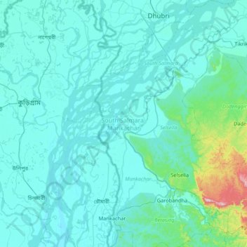
Name: South Salmara-Mankachar topographic map, elevation, terrain.
Location: South Salmara-Mankachar, Assam, India (25.46652 89.81696 26.05455 90.19636)
Average elevation: 190 ft
Minimum elevation: 43 ft
Maximum elevation: 2,096 ft
Make a donation
Gear up for your next adventure:
As an Amazon Associate, this site earns from qualifying purchases at no extra cost to you.
Other topographic maps
Click on a map to view its topography, its elevation and its terrain.
Make a donation
Gear up for your next adventure:
As an Amazon Associate, this site earns from qualifying purchases at no extra cost to you.