Geolocate

Peppara topographic map

Click on the map to display elevation.

About this map

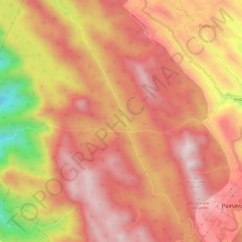
Name: Peppara topographic map, elevation, terrain.

Location: Peppara, Idukki, Kerala, India (9.85321 76.89631 9.89094 76.94869)

Average elevation: 2,464 ft

Minimum elevation: 846 ft

Maximum elevation: 3,255 ft

Other topographic maps

Click on a map to view its topography, its elevation and its terrain.

Pettimudi Hill Top

India > Kerala > Idukki

Average elevation: 2,657 ft

Muttukadu

India > Kerala > Idukki

Average elevation: 3,596 ft

Muthirapuzha

India > Kerala > Idukki

Average elevation: 1,808 ft

Idukki Dam

India > Kerala > Idukki

Average elevation: 2,300 ft

Silent vally thodu

India > Kerala > Idukki

Average elevation: 5,472 ft

Mattupetty Dam

India > Kerala > Idukki

Average elevation: 5,463 ft

Malankara Dam

India > Kerala > Idukki

Average elevation: 194 ft

Chokramudi

India > Kerala > Idukki

Average elevation: 5,479 ft

Gear up for your next adventure:

📻Weather Alert Radios - Stay informed of storm risks while off-the-grid
👟Trail Running Shoes - Lightweight shoes for trail runners
🧣Hiking Neck Gaiter - Multi‑use neck protection for outdoor weather
🔌Solar Panel Charger - Charge gear sustainably outdoors
📡GPS Antenna Upgrade - Enhance GPS reception in remote terrain

As an Amazon Associate, this site earns from qualifying purchases at no extra cost to you.