Geolocate

Muthirapuzha topographic map

Click on the map to display elevation.

About this map

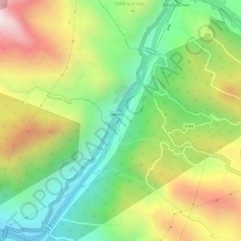
Name: Muthirapuzha topographic map, elevation, terrain.

Location: Muthirapuzha, Idukki, Kerala, 685562, India (9.95125 76.98333 9.98010 77.00149)

Average elevation: 1,808 ft

Minimum elevation: 801 ft

Maximum elevation: 3,048 ft

Other topographic maps

Click on a map to view its topography, its elevation and its terrain.

Pettimudi Hill Top

India > Kerala > Idukki

Average elevation: 2,657 ft

Nallathanni

India > Kerala > Idukki

Average elevation: 4,236 ft

Mali

India > Kerala > Idukki

Average elevation: 3,583 ft

Kunchithanny

India > Kerala > Idukki

Average elevation: 3,071 ft

Kokkayar

India > Kerala > Idukki

Average elevation: 512 ft

Kodathi

India > Kerala > Idukki

Average elevation: 285 ft

Peppara

India > Kerala > Idukki

Average elevation: 2,464 ft

Malankara Dam

India > Kerala > Idukki

Average elevation: 194 ft

Chokramudi

India > Kerala > Idukki

Average elevation: 5,479 ft

Gear up for your next adventure:

🔌Solar Panel Charger - Charge gear sustainably outdoors
🩳Quick‑Dry Hiking Shorts - Comfortable and quick‑dry shorts for summer hiking
🥘Titanium Cookware - Durable, featherlight pots and pans for backpacking
🌄Hiking Binoculars - Compact binoculars for scenic views and trail spotting
🧤Tactile Hiking Gloves - Keep hands warm while operating GPS and smartphone screens

As an Amazon Associate, this site earns from qualifying purchases at no extra cost to you.