
Soriano topographic map
Interactive map
Click on the map to display elevation.
About this map
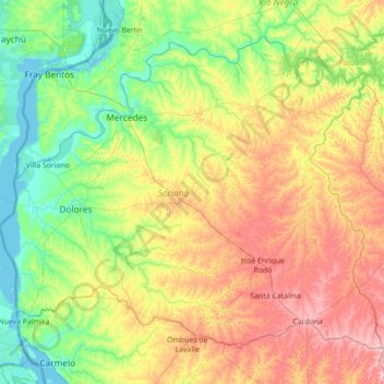
Name: Soriano topographic map, elevation, terrain.
Location: Soriano, Uruguay (-33.95560 -58.49477 -33.00012 -57.08934)
Average elevation: 203 ft
Minimum elevation: -7 ft
Maximum elevation: 653 ft
Other topographic maps
Click on a map to view its topography, its elevation and its terrain.
José Enrique Rodó
Uruguay > Soriano > José Enrique Rodó
José Enrique Rodó, Soriano, 75202, Uruguay
Average elevation: 453 ft
Pueblo Castillos
Uruguay > Soriano > Pueblo Castillos
Pueblo Castillos, Soriano, 70100, Uruguay
Average elevation: 269 ft
Chacras de Dolores
Uruguay > Soriano > Chacras de Dolores
Chacras de Dolores, Soriano, 75100, Uruguay
Average elevation: 69 ft